
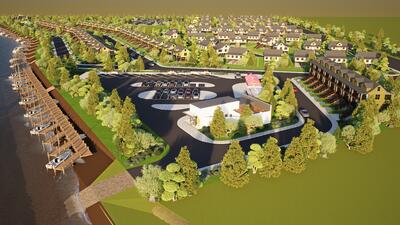
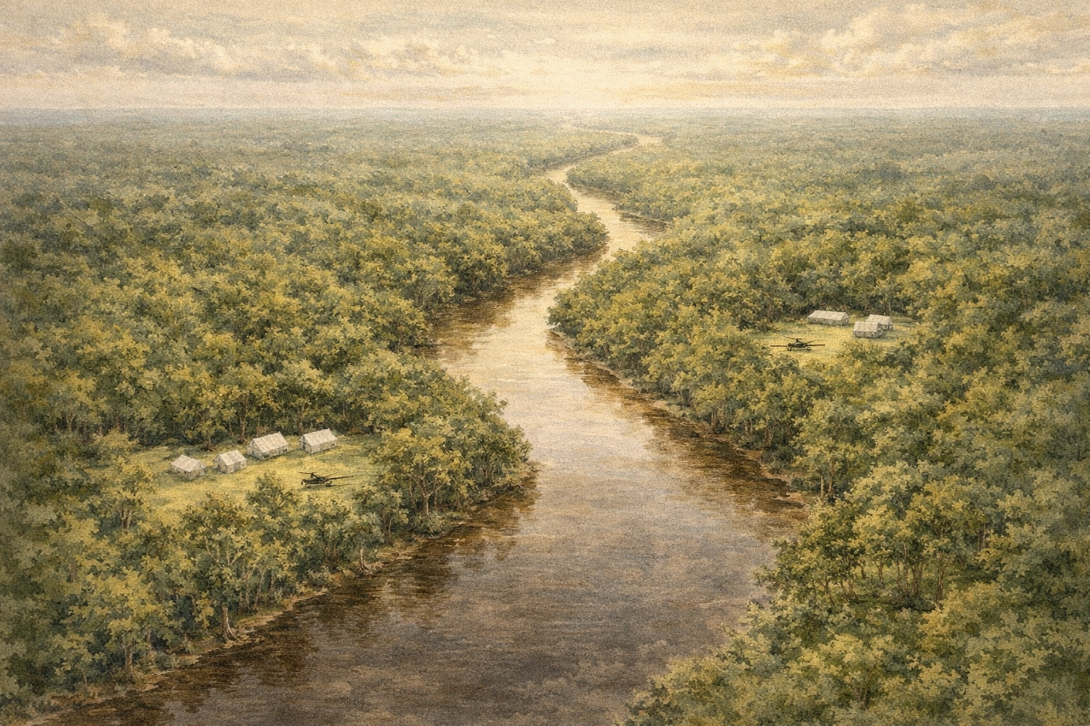
A new riverfront park designed as a public asset for the broader Hattiesburg community, not only the homes beside it.
With space for play, walking, gathering, river access, and family activity, the goal is to create something on this land that adds real civic value and gives more of the city a reason to come to the water.
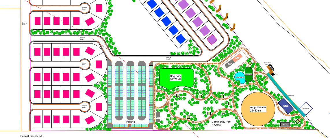
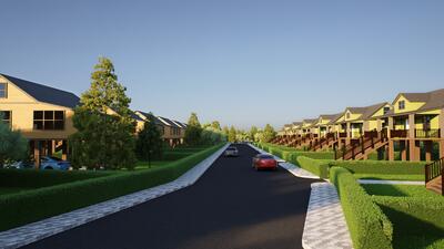
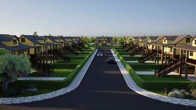
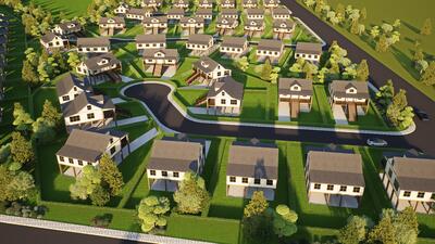
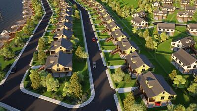
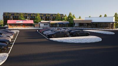
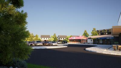
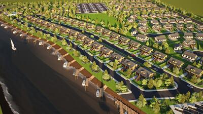
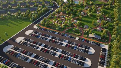
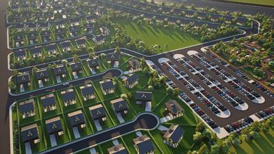
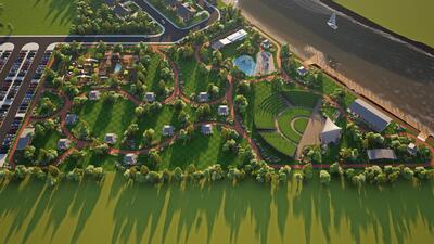
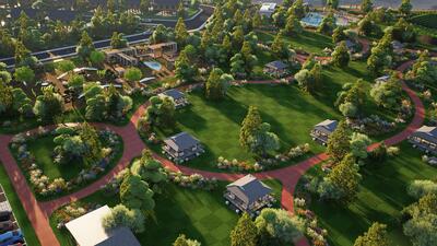
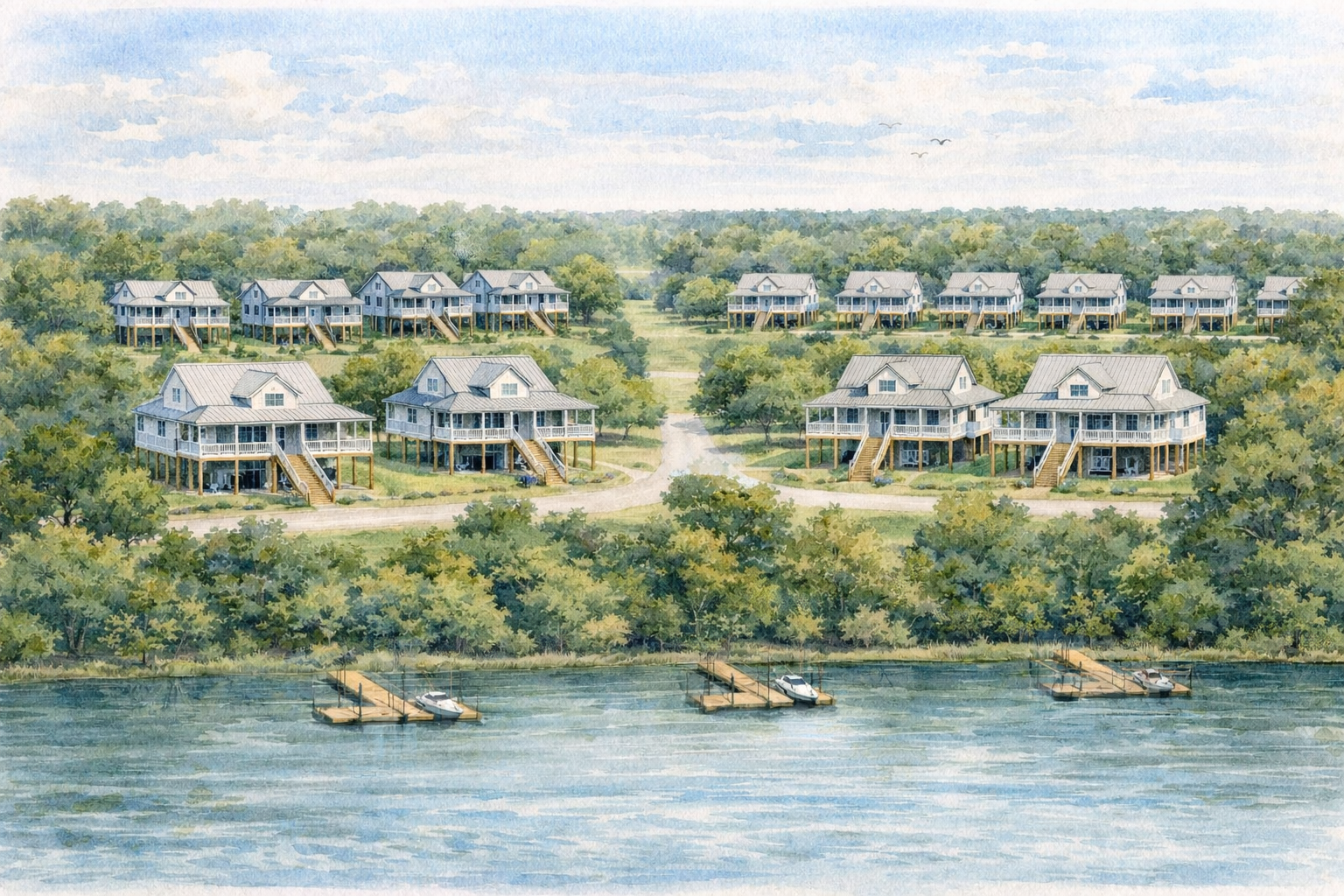
The plan brings together homes, park space, gathering areas, river access, and recreation in one connected riverfront setting.
Instead of reducing the site to a single use, the concept tries to make the most of its location on the Leaf River and turn that into broader value for Hattiesburg.
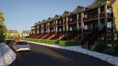
Homes designed for working households that want quality, function, and a price point that still feels possible.
Some layouts reflect real shared-living patterns, with private bedroom and bath arrangements that work well for two adults under one roof. The focus is dignity, usefulness, and value.
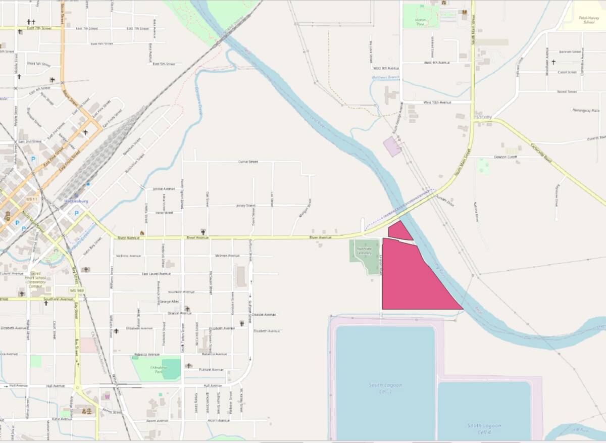
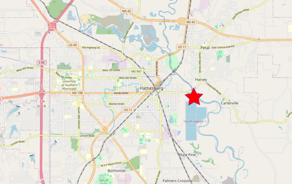
This map shows where the property sits in relation to downtown, Ward 2, and the surrounding city fabric.
The location matters. It places the project on the Leaf River, but still close enough to be part of normal Hattiesburg life and city use.
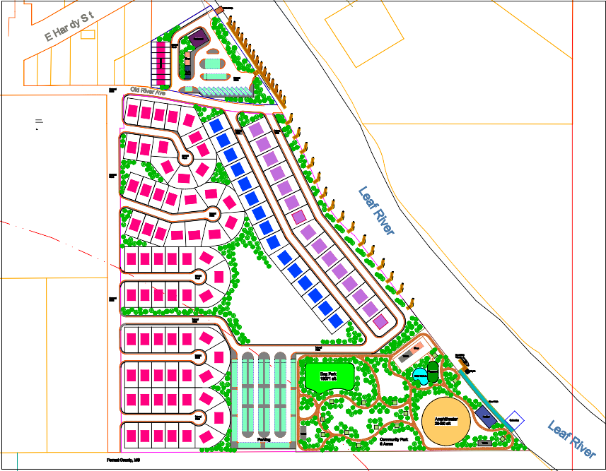
This image pulls the concept together: homes, park space, walking paths, gathering areas, and river access arranged as one connected place.
For someone moving quickly, this is the shortest way to understand the project — not every detail, but the overall logic and intent.
River Plant Vision
Architectural renderings — cypress siding with native plants and coastal designs


Eagles Flock
at Leaf River
103 Homes · 31 Acres · Hattiesburg MS
Overview
East Hattiesburg on River Avenue at the Leaf River. Direct connection to Pinebelt Blueways — 52.3 miles of paddling trail on the Leaf and Bouie rivers.
| Site | ~31 acres, three parcels |
| River Frontage | Direct Leaf River access |
| Metro Population | 157,000 |
| Major Employers | Forrest Health System, USM, Camp Shelby, William Carey |
| Component | Units/Size | Price Range |
|---|---|---|
| Standard Homes | 65 units · 1,200-1,400 SF | $200,000 - $225,000 |
| Mid-Range Homes | 15 units · 1,400-1,600 SF | $250,000 - $285,000 |
| Premium Homes | 15 units · 1,600-1,800 SF | $325,000 - $375,000 |
| Marina Townhomes | 8 units · 1,100-1,300 SF | $275,000 - $325,000 |
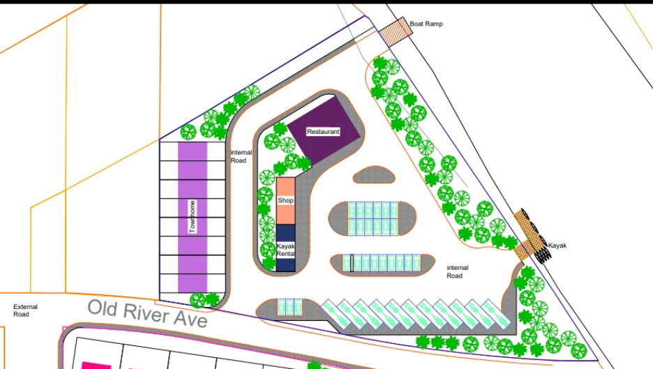
| Marina | 15 slips + boat ramp | — |
| Community Park | ~6 acres | — |
| Commercial | Restaurant + retail | — |
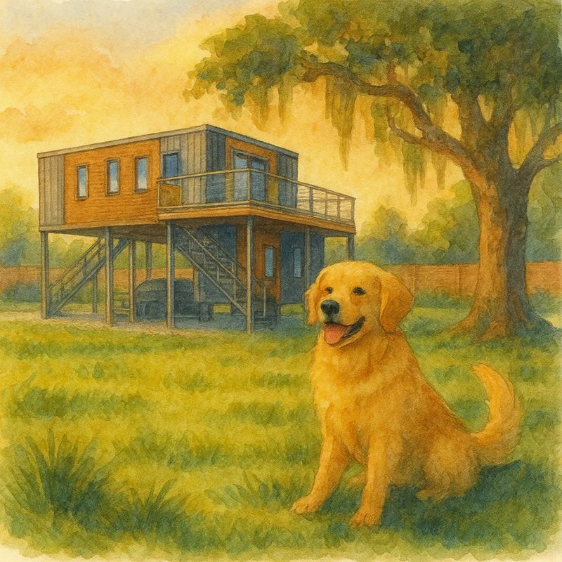
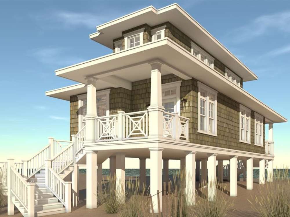
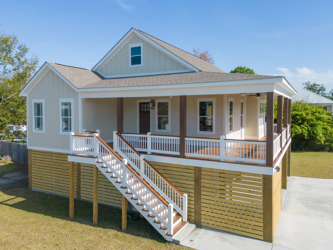
All homes elevated 10 feet above grade on timber piers. Designed for floodplain compliance with No-Rise certification where required.
| Pier Type | 8" creosote-treated timber |
| Elevation | 10 ft above grade (finished floor) |
| Flood Zone | Zone AE and Floodway |
Structural Insulated Panels (SIPs) provide R-40+ insulation. Utility costs run approximately 50% lower than conventional stick-built construction.
| Wall Assembly | SIP panels with embedded structure |
| Insulation Value | R-40+ |
| Utility Savings | ~50% vs conventional construction |
| Air Sealing | Factory-sealed joints |
Construction cost factors for SIP homes on elevated foundations.
Mississippi new home construction runs $110-$180 per square foot. National average is $154/SF.
| Mississippi average | $110 - $180/SF |
| National average | $154/SF |
| Eagles Flock Standard | $143 - $167/SF (sale price) |
Sources: NAHB Cost of Constructing a Home 2024, Houzeo, Home-Cost.com
| SIP Construction | Higher material cost, lower labor cost. Panels arrive pre-cut; walls go up in days. Net cost comparable to stick frame. |
| Elevated Foundation | Timber piers require minimal earthwork. Alternative in floodplain: import fill, build retaining structures, engineer drainage. |
| Direct Procurement | Materials purchased directly from manufacturers. Eliminates 15-25% general contractor markup. |
| Volume | 103 homes. Bulk pricing on SIP panels, appliances, HVAC, smart home components. |
Included in all homes at $200,000-$225,000:
| SIP envelope | R-40+ insulation, ~50% lower utility costs |
| Elevated foundation | 10 ft on timber piers, covered parking underneath |
| Electric tuk-tuk | Transportation to marina, park, neighbors |
| Smart home system | Usage dashboards, efficiency monitoring |
| Mini-split HVAC | Zone control, high efficiency |
| Tankless water heater | Endless hot water, lower operating cost |
Hattiesburg metro has 61,290 households. At a $200,000 purchase price, approximately 16,500 households (27%) qualify based on income. Limited new construction exists at entry-level price points.
| Purchase Price | Est. PITI | Income Needed | Households Who Qualify |
|---|---|---|---|
| $200,000 | ~$1,530/mo | $61,200/yr | ~16,500 (27%) |
| $250,000 | ~$1,905/mo | $76,200/yr | ~10,200 (17%) |
PITI estimates: 7% rate, 30-year term, FHA with PMI, taxes 0.76%, insurance $1,200/yr. Source: Census ACS 2023
| Marina Slips in Hattiesburg | None |
| Covered Boat Storage at River | None |
| Commercial Services at Ramps | None |
| Blueway Miles | 52.3 (Leaf + Bouie rivers) |
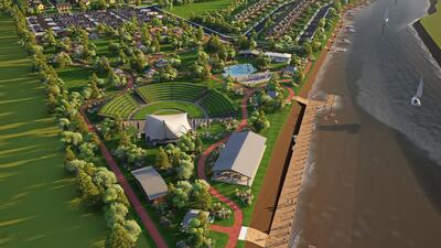
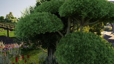
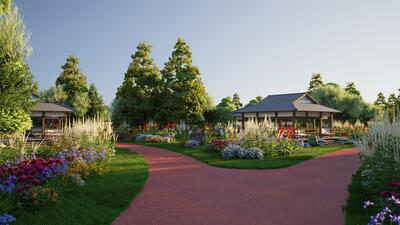
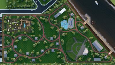
Community Park
~8 acres of riverfront parkland proposed for public use.
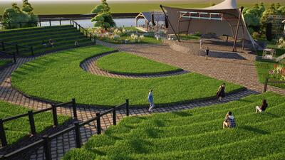
Paved loop circling the park perimeter. 2,562 feet per lap—approximately two laps per mile. 8-10 foot width accommodates walkers, joggers, and cyclists simultaneously. Connects all park amenities.
Less than half of Americans meet federal physical activity guidelines (150 minutes moderate exercise weekly). Less than half of US residents live within half-mile of a park. RAND Corporation research found walking loops are the most effective park investment for increasing physical activity across all age groups—particularly adults and seniors, populations underrepresented in traditional park amenities like sports courts and playgrounds.
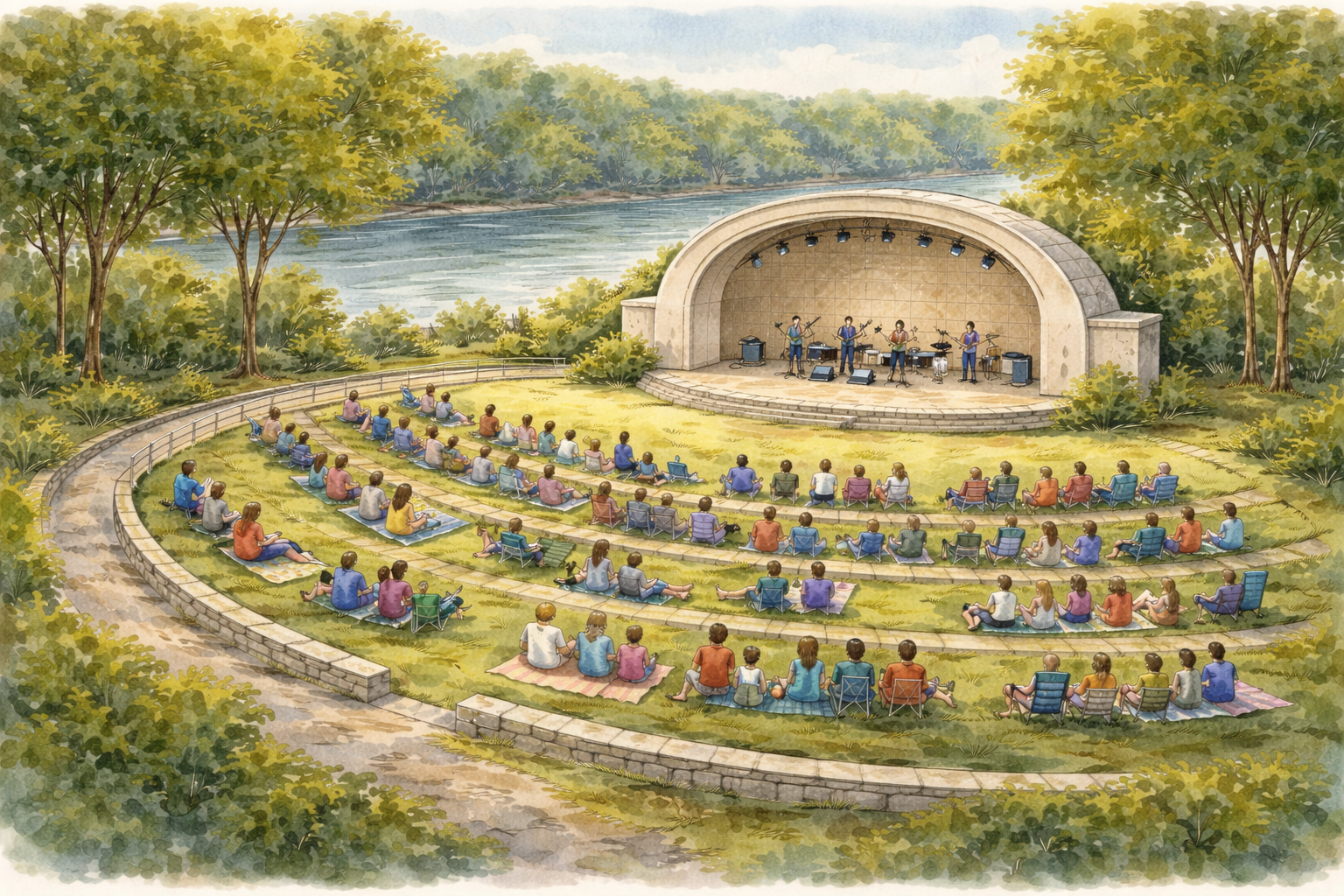
Earthen bowl amphitheater with grass-tiered seating facing the river. Concrete band shell on elevated piers. Capacity 1,250-1,500 (based on 500-car parking × 2.5 people/car plus walk-ins from neighborhood). Grass tiers 4 feet wide accommodate chairs and blankets while allowing mower access.
Riverfront amphitheaters serve as community gathering spaces for concerts, festivals, movies, and civic events. Comparable venues: Alton Amphitheater (IL) on Mississippi River seats 3,000-4,000; Montgomery Riverwalk Amphitheater (AL) on Alabama River seats 6,000; Salem Rotary Amphitheater (OR) on Willamette River seats 3,500 (funded through $4M Rotary/city partnership, 2021). The earthen depression design aids flood conveyance—water flows through rather than around the bowl.
Floating dock with low-freeboard design for easy kayak/canoe entry. ADA-accessible ramp from walking track. Helical screw anchors with chain/tension cords allow dock to rise with water level during floods.
The Pinebelt Blueways system designates 52.3 miles of paddling trails on the Leaf and Bouie Rivers. Hattiesburg invested $1M+ in the Sims Road Boat Ramp (completed November 2025) plus $480,000 from the Mississippi Outdoor Stewardship Grant program. Eagles Flock would add a second public launch point within Hattiesburg city limits. Paddlesports are among the fastest-growing outdoor recreation segments; watersport participants spend $86 billion annually (second only to camping at $142 billion).
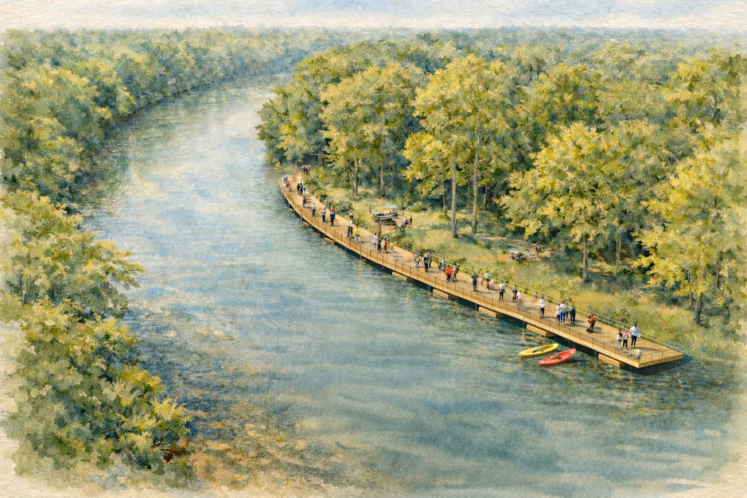
Floating boardwalk extending along the riverbank. Modular pontoon sections with non-slip decking. Helical anchors allow vertical movement with water level while maintaining horizontal position. Handrails and lighting for evening use.
River access without requiring boat ownership. Fishing platforms, wildlife observation, and scenic walking. Floating structures rise with flood waters rather than obstructing conveyance—standard practice in flood-prone rivers. Examples include marinas on the Mississippi, Illinois, and Fox Rivers using floating dock systems that have survived decades of flood cycles.
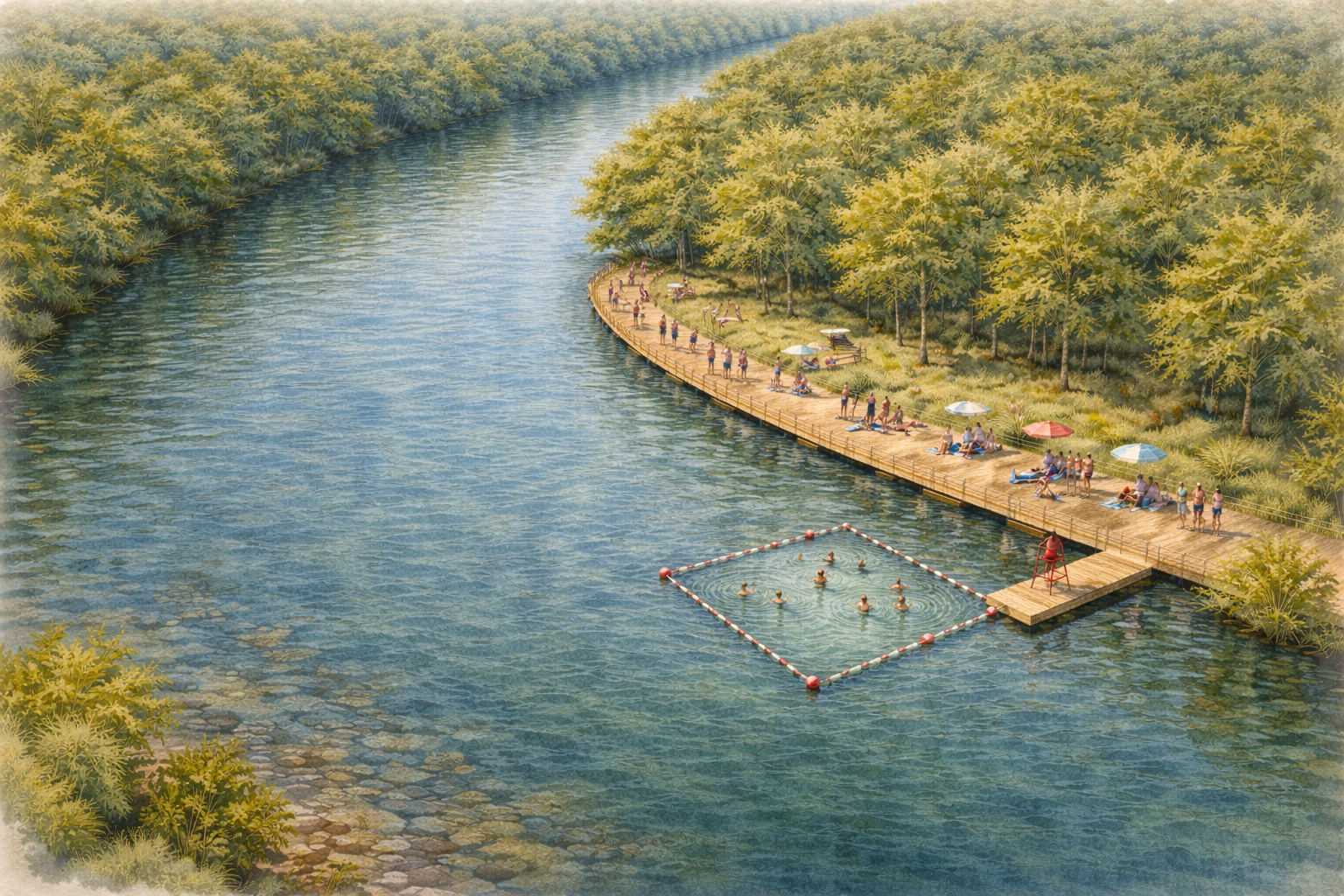
Designated swimming area at natural sandbar location. Floating boundary markers define swim zone. Floating dock provides entry point and rest area. No permanent structures in channel.
Public river swimming is returning to American cities after decades of decline. Portland (OR), Boston (MA), and communities in New Jersey have reopened river swimming as water quality has improved. The Upper Leaf River has a strong reputation for water quality; swimming at sandbars is already common practice among local residents. A designated swim area with safety infrastructure formalizes existing use.
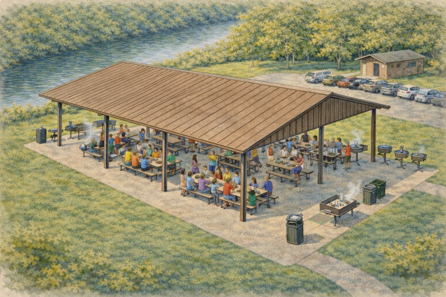
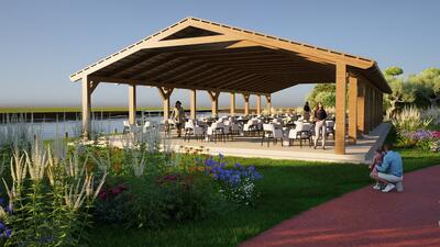
Covered pavilion with picnic tables and electrical service. Open-air design for events and gatherings. Elevated on piers above flood level with flood-vented foundation.
Reservable space for family reunions, birthday parties, corporate picnics, and community meetings. Shade and rain protection extend usable park hours and seasons. Standard municipal park amenity.
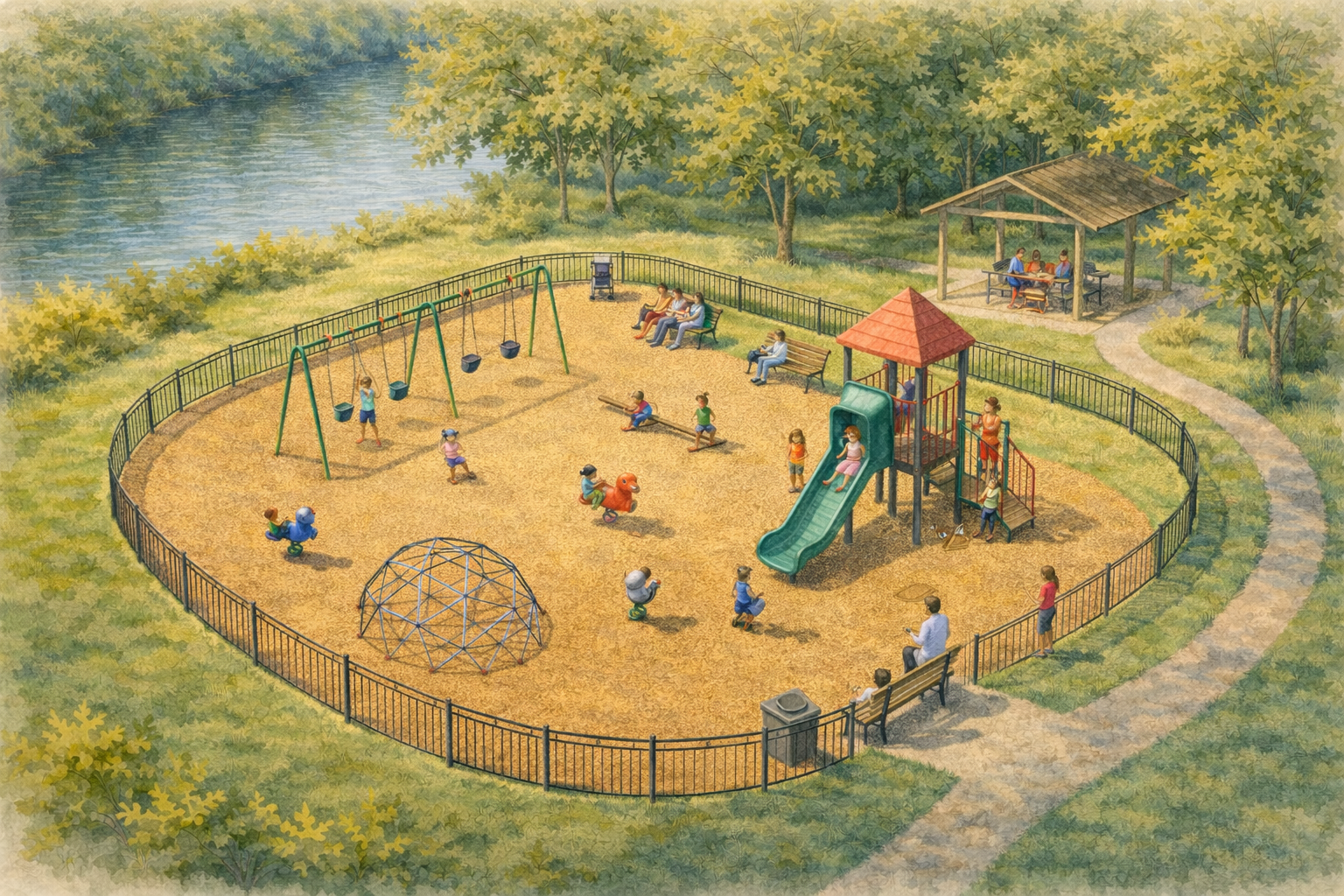
Age-appropriate play equipment on safety surfacing. Fenced perimeter provides safety near water. Shaded seating for supervising adults. Located adjacent to pavilion and walking track.
RAND Corporation research found 25% of all children's park use occurs in playgrounds—the most common facility in neighborhood parks (89%). Each additional play element increases both users and physical activity by approximately 50%. Playgrounds draw families; families use the surrounding amenities (walking track, pavilion, river access).
All park structures designed for FEMA floodway compliance. Floating docks rise with water level—no obstruction to flood conveyance. Amphitheater depression aids drainage. Pavilion and any fixed structures elevated on piers with flood venting. HEC-RAS hydraulic modeling confirms no-rise certification feasibility. These methods are standard practice for riverfront parks nationwide.
The development proposes dedicating ~8 acres as public parkland. Details including maintenance arrangements would be determined through the city approval process.
The Pinebelt Blueways system encompasses 52.3 miles of designated paddling trails. Eagles Flock's kayak launch would serve as an official access point, adding to the city's blueway infrastructure.
Hattiesburg has invested in river recreation infrastructure including the Sims Road Boat Ramp (completed November 2025) and a $480,000 Mississippi Outdoor Stewardship Grant. Eagles Flock would add a second public launch point within city limits.
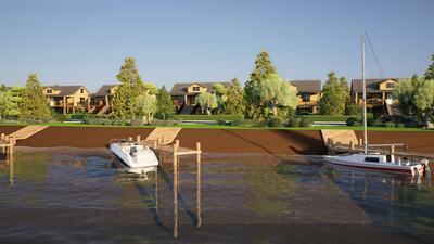
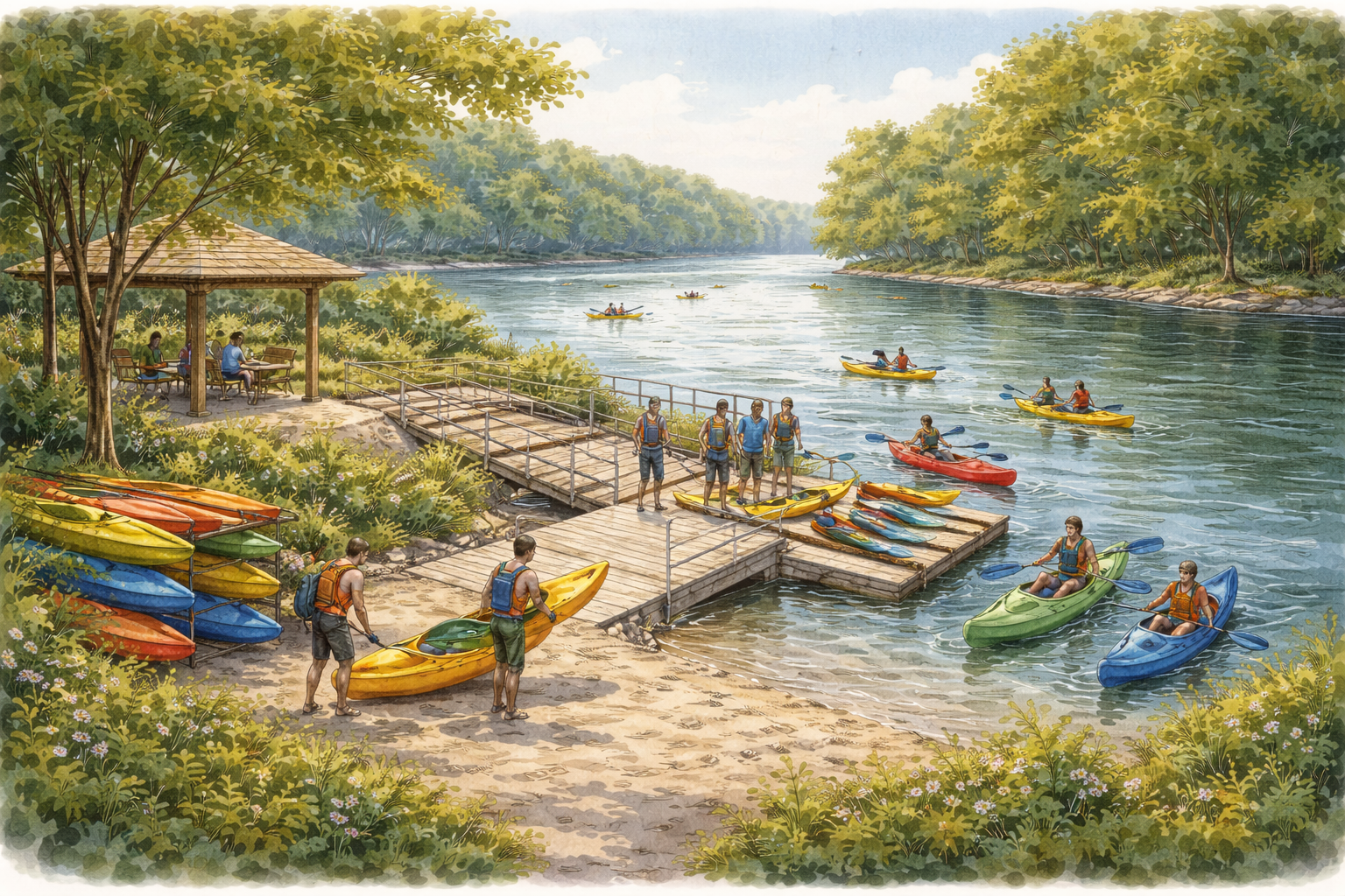
Marina
First marina on the Leaf River in Hattiesburg. Twenty-five boat slips, boat ramp, and kayak dock.
Public access boat ramp at the north tip of the property. First boat ramp on the Leaf River within Hattiesburg city limits.
| Type | Concrete, 12-15% grade |
| Access | Public |
| Connection | Pinebelt Blueways trail system |
Twenty-five boat slips anchored with helical screw anchors. Floating docks rise and fall with water level — no fixed structures in the floodway.
| Slip Count | 15 |
| Dock Type | Floating |
| Anchoring | Helical screw anchors |
| Mooring | Chain catenary system |
Helical anchors screw into the riverbed without displacing soil — compliant with floodway No-Rise requirements.
| Townhome Owners | 8 dedicated slips (one per unit) |
| Mid-Range/Premium | Priority access to remaining slips |
| Public | Available slips open to public rental |
Dedicated kayak/canoe dock at the marina. Direct launch point onto Pinebelt Blueways — 52.3 miles of paddling trail.
| Launch Type | Floating dock with rollers |
| Storage | Rack storage available |
| Trail Connection | Pinebelt Blueways |

Commercial
Waterfront restaurant and retail at the marina.
Waterfront dining overlooking the marina and Leaf River. Existing concrete slab from prior development reduces site work.
| Size | ~3,000 SF |
| Location | Marina waterfront |
| Foundation | Elevated on timber piers |
| Existing Infrastructure | Concrete slab in place |
Retail space adjacent to the restaurant. Potential uses include bait shop, convenience store, kayak rental, or marine supplies.
| Location | Marina commercial area |
| Foundation | Elevated on timber piers |
Public restroom facility serving boaters, park users, and commercial patrons.
| Size | ~1,000 SF |
| Access | Public |
| Foundation | Elevated on timber piers |
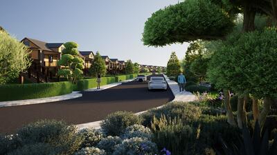
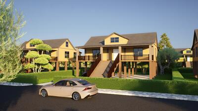
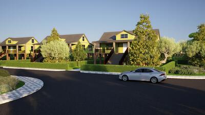
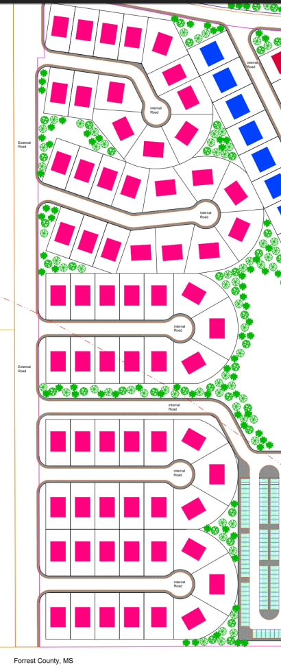
Standard Homes
65 homes in five gated clusters along Lagoon Road. $200,000 - $225,000.
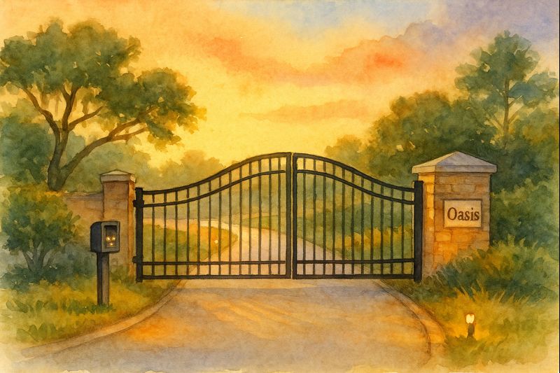
Five clusters (A through E) along Lagoon Road on the corridor parcel. Each cluster has a gated entrance.
| Total Units | 65 |
| Clusters | 5 (A, B, C, D, E) |
| Access | Gated entrance per cluster |
| Park Access | Via internal roads and tuk-tuk paths |
Every Standard home includes an electric tuk-tuk (passenger tricycle) for getting around the property — to the marina, park, restaurant, or neighboring clusters.

| Motor | 1200W |
| Battery | 60V |
| Speed | 10-15 mph |
| Range | 25-37 miles per charge |
| Capacity | Driver + 2 passengers |
Structural Insulated Panels (SIPs) form the walls and roof. Factory-sealed joints eliminate air infiltration. R-40+ insulation value.
| Wall Assembly | SIP panels |
| Insulation | R-40+ |
| Utility Savings | ~50% vs conventional construction |
| Air Sealing | Factory-sealed joints |
Homes are elevated 10 feet on timber piers. The space underneath provides covered parking — no separate garage structure required.
| Elevation | 10 ft above grade |
| Foundation | 8" creosote-treated timber piers |
| Parking | Covered, under home |
Designed for hospital staff, first responders, and others who work irregular hours.
| Bathroom Access | Not through bedroom (hallway entry) |
| Blackout Capability | All bedrooms |
| Sound Isolation | SIP panels reduce exterior noise |

| In-Unit Washer/Dryer | Yes |
| Pet Friendly | Yes |
| Mini-Split HVAC | Zone control, high efficiency |
| Tankless Water Heater | Endless hot water |
| Smart Home System | Usage dashboards |
| Size | 1,200 - 1,400 SF |
| Bedrooms | 3 |
| Bathrooms | 2 |
| Stories | 1 (elevated) |
| Parking | Covered, under home |
| Price Range | $200,000 - $225,000 |
| Est. PITI (7%, 30yr, FHA) | ~$1,530 - $1,720/mo |
| Income to Qualify | ~$61,200 - $68,800/yr |
PITI includes taxes (0.76%) and insurance (~$1,200/yr). FHA with PMI assumed.
Mid-Range Homes
15 homes on larger lots with river views. $250,000 - $285,000.
Interior entrance road on the River Roads parcel. River views from elevated living areas. Not on the riverbank, but within sight of the water.
| Total Units | 15 |
| Parcel | River Roads (interior lots) |
| Lot Size | Larger than Standard |
| Views | River visible from living areas |
Mid-Range homeowners have priority access to marina slips (after Townhome dedicated slips are allocated). Slip rental is separate.
| Slip Type | Floating (at marina) |
| Access | Priority for Mid-Range/Premium owners |
| Distance to Marina | Short drive or tuk-tuk ride |
Same Structural Insulated Panel construction as all homes in the development.
| Wall Assembly | SIP panels |
| Insulation | R-40+ |
| Utility Savings | ~50% vs conventional construction |
Elevated 10 feet on timber piers with covered parking underneath.
| Elevation | 10 ft above grade |
| Foundation | 8" creosote-treated timber piers |
| Parking | Covered, under home |
| In-Unit Washer/Dryer | Yes |
| Pet Friendly | Yes |
| Mini-Split HVAC | Zone control |
| Tankless Water Heater | Yes |
| Smart Home System | Usage dashboards |
| Size | 1,400 - 1,600 SF |
| Bedrooms | 3 |
| Bathrooms | 2 |
| Stories | 1 (elevated) |
| Parking | Covered, under home |
| Price Range | $250,000 - $285,000 |
| Est. PITI (7%, 30yr, FHA) | ~$1,905 - $2,170/mo |
| Income to Qualify | ~$76,200 - $86,800/yr |
PITI includes taxes (0.76%) and insurance (~$1,200/yr). FHA with PMI assumed.
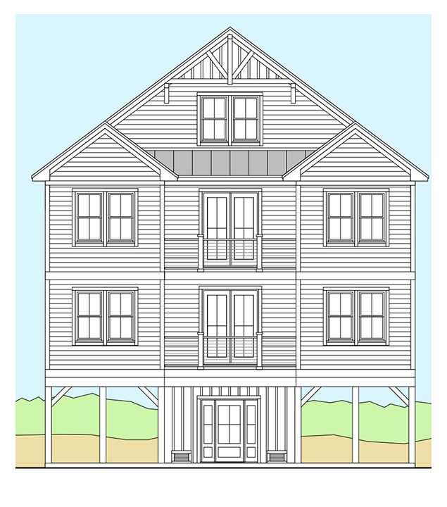
Marina Townhomes
8 two-story townhomes at the marina. Dedicated boat slip included. $275,000 - $325,000.
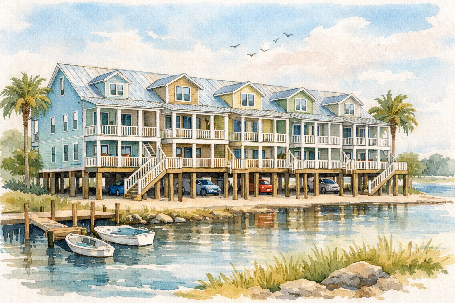
Marina parcel, steps from the floating docks. Two-story design on elevated foundation.
| Total Units | 8 |
| Parcel | Marina |
| Stories | 2 |
| Distance to Slips | Walking distance |
Each townhome includes one dedicated floating boat slip at the marina. The slip conveys with the property.
| Slip Ownership | Dedicated (conveyed with home) |
| Slip Type | Floating |
| Slip Count per Unit | 1 |
| Distance | Walk from front door |
Same Structural Insulated Panel construction as all homes in the development.
| Wall Assembly | SIP panels |
| Insulation | R-40+ |
| Utility Savings | ~50% vs conventional construction |
Elevated on timber piers with covered parking underneath.
| Elevation | 10 ft above grade (ground floor) |
| Foundation | Timber piers |
| Parking | Covered, under home |
| In-Unit Washer/Dryer | Yes |
| Pet Friendly | Yes |
| Mini-Split HVAC | Zone control |
| Tankless Water Heater | Yes |
| Smart Home System | Usage dashboards |
| Size | 1,100 - 1,300 SF |
| Bedrooms | 2 |
| Bathrooms | 2 |
| Stories | 2 (elevated) |
| Parking | Covered, under home |
| Boat Slip | 1 dedicated, included |
| Price Range | $275,000 - $325,000 |
| Est. PITI (7%, 30yr, FHA) | ~$2,095 - $2,475/mo |
| Income to Qualify | ~$83,800 - $99,000/yr |
PITI includes taxes (0.76%) and insurance (~$1,200/yr). FHA with PMI assumed. Price includes dedicated boat slip.
Premium Homes
15 homes with direct river frontage and private floating dock. $325,000 - $375,000.

River Road on the River Roads parcel. These are the only homes with direct river frontage — the backyard extends to the riverbank.
| Total Units | 15 |
| Parcel | River Roads (riverbank lots) |
| Lot Size | Largest in development |
| River Access | Direct — backyard to riverbank |
Each Premium home includes a private floating dock on the property. Launch kayaks, tie up boats, or fish from your own dock.
| Dock Type | Floating (rises/falls with water) |
| Location | On property (riverbank) |
| Anchoring | Helical screw anchors |
| Ownership | Private (conveyed with home) |
Same Structural Insulated Panel construction as all homes in the development.
| Wall Assembly | SIP panels |
| Insulation | R-40+ |
| Utility Savings | ~50% vs conventional construction |
Elevated 10 feet on timber piers with covered parking underneath.
| Elevation | 10 ft above grade |
| Foundation | 8" creosote-treated timber piers |
| Parking | Covered, under home |
| In-Unit Washer/Dryer | Yes |
| Pet Friendly | Yes |
| Mini-Split HVAC | Zone control |
| Tankless Water Heater | Yes |
| Smart Home System | Usage dashboards |
| Size | 1,600 - 1,800 SF |
| Bedrooms | 3-4 |
| Bathrooms | 2 |
| Stories | 1 (elevated) |
| Parking | Covered, under home |
| Private Dock | Yes, on property |
| Price Range | $325,000 - $375,000 |
| Est. PITI (7%, 30yr, conv) | ~$2,380 - $2,745/mo |
| Income to Qualify | ~$95,200 - $109,800/yr |
PITI includes taxes (0.76%) and insurance (~$1,400/yr). Conventional financing assumed at this price point. Price includes private floating dock.
Conceptual Floor Plans
Representative layouts under consideration. All drawings are conceptual illustrations — not engineered plans. Final configurations determined during design-build.
Designing for structural insulated panels (SIPs) differs from conventional framing. These layouts help verify cost-per-square-foot targets while communicating design intent. They are not comprehensive architectural drawings — they are inspiration for an architect experienced in SIP construction.

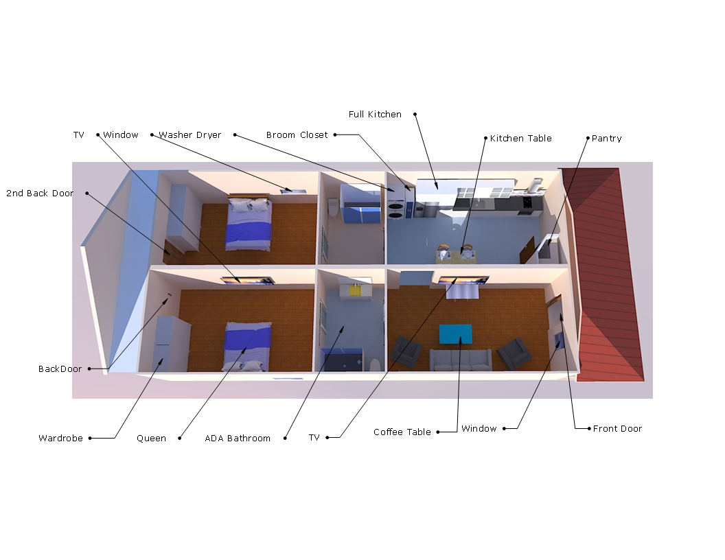
| Bedrooms | 2 |
| Bathrooms | 2 |
| Target Size | ~900-1,100 SF |
| Used In | Marina Townhomes |

| Bedrooms | 3 |
| Bathrooms | 3 |
| Target Size | ~1,200-1,800 SF |
| Used In | Standard, Mid-Range, Premium |
| Bathroom Access | Hall entry — not through bedroom |
| Blackout Capability | All bedrooms |
| Sound Isolation | SIP panels reduce noise transfer |

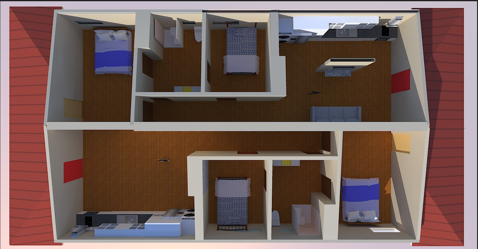
| Units | 2 attached |
| Configuration | Side-by-side, shared wall |
| Each Unit | Independent entrance, utilities, parking |
| Use Case | Owner-occupant with rental income, multi-generational |
How These Homes Are Built
Every system is specified for accurate pricing. Buyers: scan the table. Builders: expand any row for material specs and installation detail.
| Feature | Advantage | Benefit |
|---|---|---|
| SIP panel walls & roof | Continuous R-40+ insulation, no thermal bridging. Walls up in 2 days. | ~50% lower utility bills. $75-$125/month operating cost. |
| 10 ft timber pier elevation | No fill dirt, no slab, no retaining walls. Covered parking underneath. | Floodplain-compliant. Free covered parking. No flood insurance surprises. |
| Wall Panel | 6.5" EPS core, 7/16" OSB faces |
| Roof Panel | 10.25" EPS core, 7/16" OSB faces |
| R-Value | Walls R-24, Roof R-40 (continuous — no stud bridging) |
| Joint Sealing | Factory spline + field tape at all seams. Blower door tested. |
| Delivery | Factory-cut to plan, labeled, crane-set. Pre-routed electrical chases. |
| Install Timeline | 2-day framing per home (walls + roof deck). 1 crane day. |
| Trades on Site | 2-person SIP crew + crane operator. No separate insulation trade. |
| Pier Type | 8" diameter creosote-treated timber |
| Spacing | 8' OC typical (verify with structural) |
| Beams | Triple 2×12 PT or steel W-flange (per structural) |
| Elevation | 10 ft above grade (BFE + freeboard) |
| Footings | Concrete pier pads, sized per soil bearing |
| Stair/Deck Allowance | $6,000 - $8,000 per home (exterior stairs + entry deck) |
| Flood Zone | AE / Floodway. No-Rise certification in progress (PE: Jill Butler, River Science). |
| Feature | Advantage | Benefit |
|---|---|---|
| Mini-split HVAC | No ductwork. Heat and cool only occupied rooms. | Quieter. Each room its own thermostat. Lower energy waste. |
| Tankless gas water heater | On-demand hot water. No standby heat loss. | Endless hot water. Works during power outages. Smaller footprint. |
| Manifold PEX plumbing | Home-run lines, no joints in walls. Individual fixture shutoffs. | Leak at one fixture — shut off that line, everything else runs. |
| Generator-ready propane hookup | Propane line already in for water heater. Generator plug-and-play. | $300-$800 generator covers whole house in any outage. |
| Configuration | 2-3 indoor heads per home (1 living area, 1-2 bedrooms) |
| Total Capacity | 18,000-24,000 BTU (SIP envelope runs 40-60% smaller than conventional sizing) |
| Electrical | 120V / 15A per indoor head. One 240V / 20A outdoor condenser. |
| Refrigerant Lines | Pre-charged linesets, routed through SIP utility chase |
| Mounting | High-wall indoor units. Condenser on pier-level pad or wall bracket. |
| Water Heater | Gas tankless, 8-10 GPM (sized for 3BR/2BA simultaneous use) |
| Gas Line | 3/4" from propane stub to unit. Shared line with generator hookup. |
| Venting | Direct vent through exterior wall. Concentric vent kit. |
| Ignition | Electronic — small electric draw, works on generator power |
| Manifold Location | Utility closet, accessible without wall tearout |
| PEX Runs | 3/8" or 1/2" home-run to each fixture. No in-wall fittings. |
| Pressure Test | 80 PSI for 30 minutes, all lines, before drywall |
| Generator Hookup | 30A inlet box, manual transfer switch or interlock, 10/3 wire to panel |
| Feature | Advantage | Benefit |
|---|---|---|
| 24V DC LED lighting | Lower voltage, lighter wire, direct solar-ready. | Lighting costs pennies. Safer wiring. Add solar without retrofit. |
| 55-amp electrical panel | SIP + mini-splits + gas appliances = home draws half the power. | Smaller panel, lighter wiring. Lower install cost in sale price. |
| Convection oven (gas or 120V) | No 240V circuit for range. One less heavy electrical run. | Cooks faster and more evenly. Simpler electrical, lower cost. |
| Solar-ready conduit | Empty conduit roughed in during framing. | Add solar on your schedule. No tearing into finished walls. |
| 24V Transformer | 120V AC to 24V DC, mounted in panel area. Powers all LED lighting. |
| 24V Wire | 14-16 AWG (lighter than 120V 12 AWG). Separate bus from AC circuits per NEC. |
| LED Fixtures | 24V DC rated. No ballast, no conversion loss. Dimmable. |
| Panel Load Calc | No 240V range, no 240V water heater. Mini-splits: 1×240V condenser + 2-3×120V heads. 24V transformer: ~5A at 120V. Result: 55A service adequate. |
| Solar Conduit | 1" EMT from south-facing attic penetration to panel. Pull string installed, labeled both ends. $200-$400 installed. |
| Feature | Advantage | Benefit |
|---|---|---|
| Smart home dashboard | Real-time utility monitoring per system. | See where your money goes. Data shows which habits save most. |
| LoRaWAN security & emergency | AI emergency support, call buttons, mesh network across all 103 homes. | Gated clusters + mesh network. Not dependent on WiFi or cell. |
| Hub | Home Assistant (open source). One per home. Local control, no cloud subscription. |
| Monitoring | Circuit-level energy, leak detection at manifold and water heater, door/window sensors |
| LoRaWAN Gateway | 1 gateway covers all 103 homes. 10+ year battery on sensors. |
| Emergency System | Wired panic buttons in each home. Mesh routes to gateway independent of internet. |
| Rough-In | Cat6 to hub location, low-voltage ring in each room, conduit for future sensor wiring |
| Feature | Advantage | Benefit |
|---|---|---|
| Electric tuk-tuk (included) | On-site transportation — marina, park, neighbors. | No second car needed. Charges from standard outlet. |
| 25-slip marina | First marina in Hattiesburg. Leaf River + Pinebelt Blueways. | River access from your neighborhood. |
| 6-acre community park | Amphitheater, walking track, playground. Donated to city. | No HOA fees. City maintains it. Anchors property values. |
| Rain gardens | Stormwater managed on-site through engineered landscaping. | No concrete detention ponds. Looks like garden, works like infrastructure. |
| Tuk-Tuk Charging | Standard 120V outlet at each home. 60V battery, 6-8 hour charge cycle. |
| Marina | 25 slips on Leaf River. Separate permitting (USACE Section 404/10). Not in home construction scope. |
| Park | 6 acres, dedicated to City of Hattiesburg. Amphitheater, 1/4 mile track, playground. Separate site work contract. |
| Rain Gardens | Engineered bioretention per MS DEQ stormwater requirements. Sized per impervious area calcs. Landscape contract. |
| Roads/Utilities | Internal roads, water/sewer extensions, electrical service — all separate land improvement contracts. |
Procurement
Every component is individually priced and directly sourced. No hidden markups. Full cost visibility from design through installation.
Each building component is catalogued with detailed specifications and priced individually using low/expected/high estimates. Materials, labor, general conditions, and contingency are broken out separately.
| Pricing Model | Low / Expected / High per component |
| Cost Layers | Materials, labor, general conditions, contingency — each visible |
| Tracking | QR code per component for traceability from order through install |
| Updates | Real-time cost tracking as bids come in and materials are purchased |
Suppliers bid through a qualification portal with standards equivalent to Alabama Institute of Architects requirements.
| Experience | Minimum 5 years in relevant construction or manufacturing |
| Financial | 3 years audited statements, bonding capacity, insurance |
| Performance | >95% on-time delivery, <2% defect rate, safety record |
| Documentation | Specs, warranties, regulatory compliance, digital integration |
103 homes using identical systems create volume procurement leverage. Direct supplier relationships eliminate general contractor markup on materials.
| Scale | 103 homes — same SIP specs, same mechanical, same electrical |
| Savings | ~5% of total development cost through direct procurement |
| Transparency | Investors and partners see every line item |
| Multiple Suppliers | No single-source dependency on any component category |
Full procurement platform, component trees, and cost calculators: qplex.nsgia.com/procurement
The Land & The River
A reference guide for visitors to the upper Leaf River at Hattiesburg.
The upper Leaf River near Hattiesburg has an excellent reputation for water quality. Paddlers regularly swim at sandbars throughout this section. The Seven Rivers Canoe Club documents swimming at confluence points and sandbars as routine.
The Leaf runs warmer than its tributaries. At the Oakahay Creek confluence, paddlers note the Leaf is "markedly warmer and of a lighter, muddy tint" than incoming streams. The river is deeper with stronger current at these points—swimming into the main channel from tributaries requires awareness that combined currents may push swimmers downstream.
Water Quality Context: A 1990s lawsuit alleged pollution from a Georgia-Pacific pulp mill on the lower Leaf River (downstream, toward the Gulf). Courts dismissed the case in 1996, finding no scientific proof of dangerous dioxin levels. The upper Leaf near Hattiesburg—the section adjacent to this property—was not part of that litigation and maintains its reputation as clean water.
Fish Consumption: Mississippi Department of Wildlife, Fisheries and Parks rates upper Leaf water quality as "average to above average." The Leaf River does not appear on Mississippi's Fish Consumption Advisory list.
After Heavy Rain: Standard river safety applies. Avoid swimming within 48 hours of major rain events when bacteria levels temporarily spike from runoff.
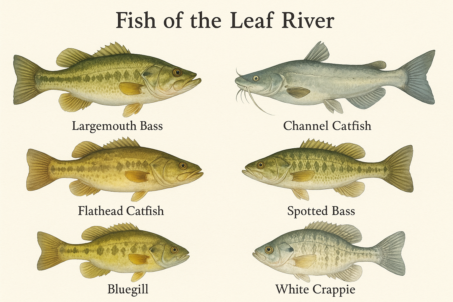
The Leaf River supports diverse gamefish populations. MDWFP documents:
Bass Species: Largemouth bass, Spotted bass, Striped bass
Catfish Species: Channel catfish, Flathead catfish, Blue catfish, Yellow catfish
Panfish: Bluegill/Bream, White crappie, Black crappie
Other Species: Freshwater drum, Paddlefish (spawning runs), Gulf sturgeon (protected, catch and release only), Alabama shad
Habitat: The river is described as "full of trees, stumps, ever-changing bottom structure"—excellent cover for fish populations. Numerous sandbars and shallows alternate with deeper pools.
River characteristics vary by section and water level. At the Hattiesburg gauge:
Normal Conditions: The river runs wide with alternating deep pools and shallow sandbars. Paddlers describe sections as "very deep and wide" at confluences.
High Water Reference: When the Hattiesburg gauge reads over 5 feet, the river runs deep throughout with strong current. At these levels, combined currents are too much to swim against.
Current: Flow varies significantly. Headwinds can make paddling difficult on wider sections. Current strengthens at tributary confluences and through narrower channels.
Real-Time Data: USGS maintains a streamgage at Hattiesburg (Station 02473000) with current depth and flow readings available online.
The Leaf River floods periodically. Major recorded crests at Hattiesburg:
| Date | Crest Height | Notes |
|---|---|---|
| April 15, 1974 | 34.03 feet | All-time record. 6,000 evacuated from Forrest County. |
| February 1961 | 31.53 feet | Record at that time. Nearly 5,000 evacuated. |
| April 1983 | Major flood | Bridges washed out, 300+ structures damaged. $50M damages. |
Context: The Eagles Flock property includes land in both the regulatory floodway and Zone AE. All construction is designed for elevated pier foundations to meet flood requirements.
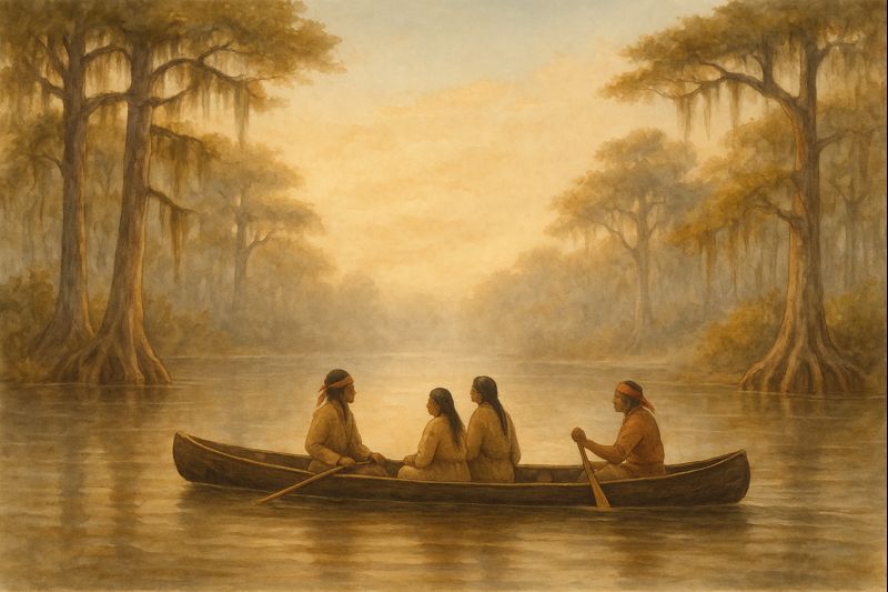
The Choctaw people inhabited this region for centuries before European contact. The upper Leaf River watershed was homeland to the Okla Hannali—the "Six Towns" division, one of three principal Choctaw political groups.
The Three Divisions:
- Okla Falaya ("Long People") — Western division, upper Pearl River
- Okla Tannap ("People on the Other Side") — Eastern division, Tombigbee River area
- Okla Hannali ("Six Towns People") — Southern division, upper Leaf River and mid-Chickasawhay River watersheds
The Six Towns villages concentrated in present-day Jasper, Newton, and Clarke counties—directly upstream from Hattiesburg.
The Leaf River carried multiple Choctaw names, all sharing linguistic roots meaning "creek" or "river": Hashuphatchee, Hastabucha, Hastehatchee, Estapacha, Estopacha, Slapacha, Tallahoma.
The suffixes "-hatchee" and "-bucha" derive from Choctaw words for creek or river. These names appear on French colonial maps and in early American survey records.
How "Leaf River" Emerged: English-speaking settlers translated or adapted the indigenous name. The exact derivation is unclear—possibly a translation of a Choctaw descriptive term, or an English name based on the river's appearance.
The Leaf River served as a trade route before roads existed. Historical records document regular trading trips from Pascagoula (on the Gulf Coast) upriver to Choctaw settlements. Traders brought manufactured goods and supplies to Six Towns villages. The river provided the primary transportation corridor through this region.
Human use of the Leaf River corridor extends back at least 25,000 years based on archaeological evidence from the broader Pascagoula watershed.
The Spanish Coins Legend: Local tradition holds that Spanish traders cached coins somewhere along the upper Leaf River. Whether fact or folklore, the story reflects the river's long history as a commercial corridor connecting the Gulf Coast to interior settlements.

The Leaf River corridor lies within the Southern Pine Hills region. Forest composition varies by elevation and moisture:
Uplands: Longleaf pine, slash pine, loblolly pine. Historic longleaf savanna largely converted to pine plantation or mixed forest.
Bottomlands: Sweetgum, water oak, willow oak, tupelo, cypress (in wetter areas). Dense understory typical.
River Edge: River birch, sycamore, willow. Sandbars may support early-succession species.
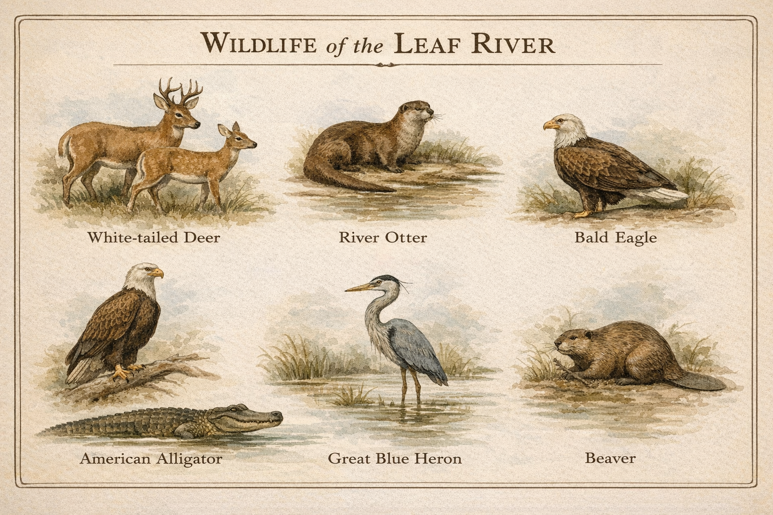
Mammals: White-tailed deer (paddlers report seeing deer wading across the river), Wild hogs, Raccoon, Opossum, Beaver, River otter, Gray and fox squirrels, Black bear (population recovering; occasional sightings)
Birds: The Pascagoula River system supports 327 documented bird species. Notable: Bald eagle (confirmed along the Leaf River), Great blue heron, various waterfowl, Wild turkey, Northern bobwhite, Red-cockaded woodpecker (endangered)
Reptiles: American alligator (Mississippi's official state reptile), various turtles including snapping turtles, multiple nonvenomous snake species
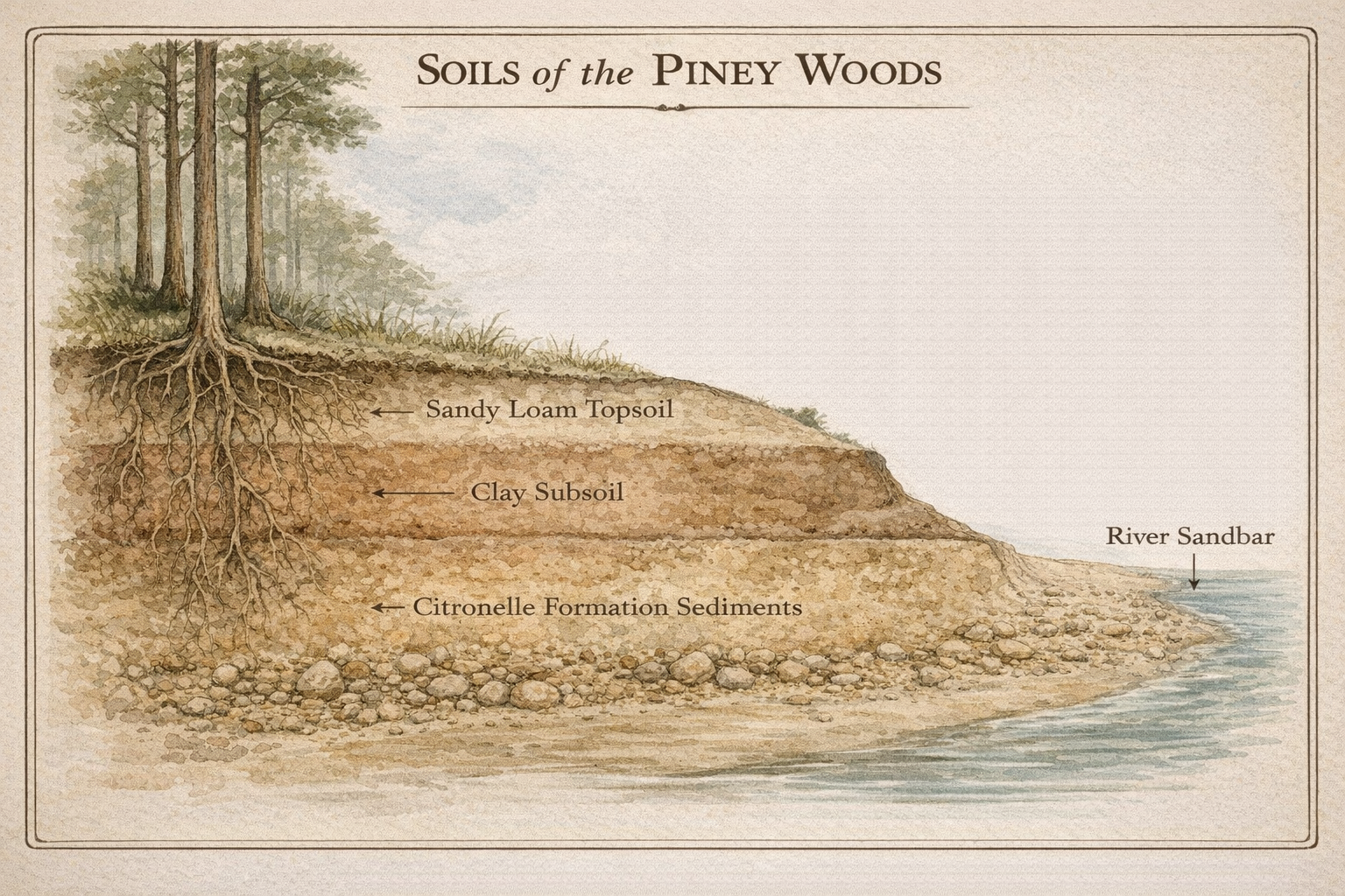
The Hattiesburg area lies within the Southern Coastal Plain geological region, specifically the Piney Woods subregion.
Soil Characteristics: Mixture of sand and clay. Sandy loam topsoil over clayey subsoil typical. Acidic pH (pine and oak decomposition produces organic acids). Low to moderate native fertility. Well-drained on uplands; wet in bottomlands.
Geological Formation: The Citronelle Formation underlies this area—ancient marine and fluvial sediments deposited on the edges of prehistoric seas. The geology dates to when the Gulf of Mexico extended much further inland.
Sandy. The Piney Woods soils developed from unconsolidated sediments, not bedrock. River sandbars throughout the Leaf are prominent features—paddlers describe "numerous beautiful sand bars" and "white sandbars" along the entire corridor.
Upland soils contain more clay than bottomland soils. The typical profile: sandy loam surface layer over clay or clay loam subsoil.
No significant rock outcrops occur in this region. The nearest limestone and chalk formations are in the Blackland Prairie region to the north.
Coastal Plain soils generally support construction with proper site preparation.
Favorable Factors: No bedrock to excavate. Sandy soils easy to work. Established construction history throughout region.
Site-Specific Factors: Clay content varies; shrink-swell clays require appropriate foundation design. Drainage critical on sites with shallow water table. Flood zone determination essential for sites near river.
The Eagles Flock property is within regulatory flood zones (floodway and Zone AE). All structures are designed for elevated pier foundations.
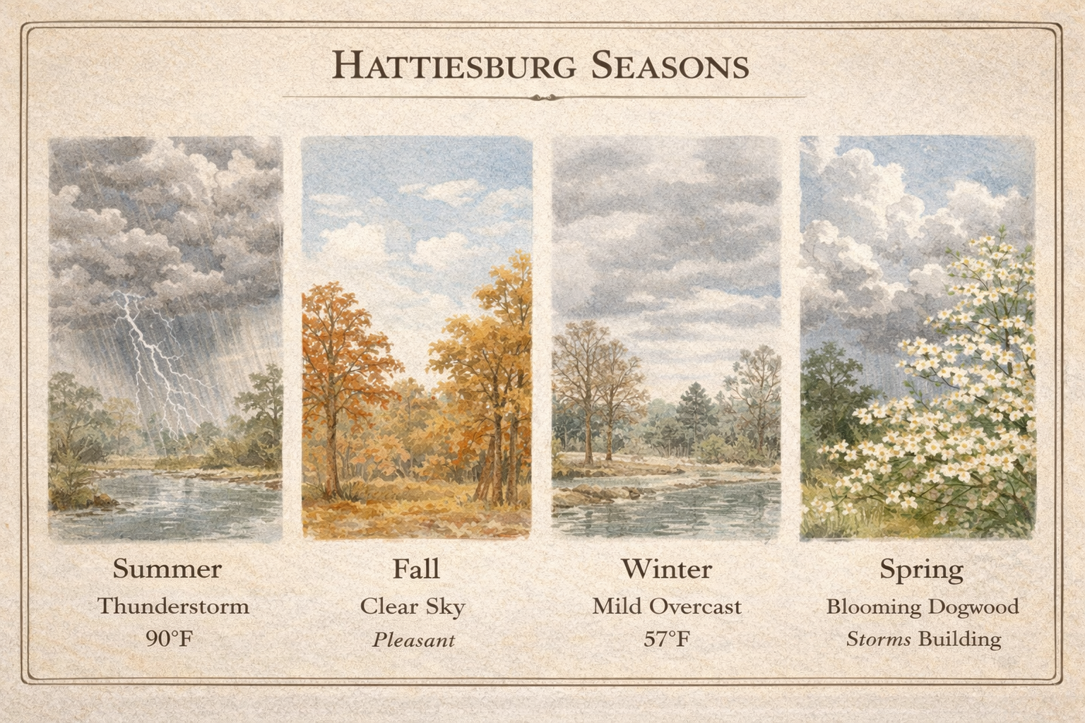
Hattiesburg has a humid subtropical climate (Köppen classification: Cfa).
Characteristics: Long, hot, humid summers. Short, mild winters. Rainfall distributed throughout the year. No dry season.
| Season | Avg High | Avg Low | Notes |
|---|---|---|---|
| Summer (Jun–Aug) | 90–91°F | 70–72°F | Hot season mid-May through late September |
| Fall (Sep–Nov) | 67–88°F | 47–67°F | Pleasant; driest months |
| Winter (Dec–Feb) | 57–65°F | 40–43°F | Mild; occasional freezes |
| Spring (Mar–May) | 72–85°F | 49–63°F | Warming rapidly; thunderstorm season begins |
Hottest Month: July (average high 91°F). Coldest Month: January (average high 61°F).
Annual precipitation averages approximately 50–61 inches, among the highest in Mississippi.
Wettest Period: July (most rainy days, 16.4 days average)
Driest Period: October (fewest rainy days, 6.6 days; lowest total rainfall, 3.1")
Pattern: Summer rainfall comes primarily from afternoon thunderstorms. Winter/spring rainfall from frontal systems moving through the region.
General Outdoor Activities: Early April through late May. Mid-September through late October. Peak conditions: First week of October.
Water Activities (Swimming, Paddling): Mid-May through late September. Peak conditions: First week of September.
Growing Season: 8.5 months (approximately March 6 through November 21). First spring blooms typically appear around January 20. Frost-free period averages 260 days.
Thunderstorms: 55–75 days per year with thunderstorm activity. Frequency increases moving south toward the Gulf Coast.
Hurricanes: South Mississippi is within the hurricane impact zone. Hattiesburg lies 75 miles inland—far enough to avoid direct coastal impacts but subject to heavy rain, wind, and flooding from major storms. Hurricane Camille (1969) produced 120 mph sustained winds at Columbia, Mississippi.
Tornadoes: Mississippi lies within "Dixie Alley"—the southeastern tornado zone. Spring months carry highest risk.
The Middle Leaf Route runs 9.6 river miles from Chain Park to Sims Road. Eagles Flock is in the upper reach — a short paddle from Chain Park, with a longer stretch downstream to Sims Road.
The Pinebelt Blueways is a 52.3-mile designated paddle trail on the Leaf and Bouie rivers, stretching from Jones County to Perry County. The trail system features signage at launch points, mile markers along the water, and educational information about wildlife and habitats encountered along the way.
The Piney Woods Conservation Group developed the blueways with funding from the Federal Highway Administration's Recreational Trails Program, administered by Mississippi Department of Wildlife, Fisheries and Parks. Partners include the City of Hattiesburg, Forrest County Board of Supervisors, Visit Hattiesburg, and Georgia-Pacific Leaf River Cellulose.
Phase 1 opened in 2018 with 10.8 miles on the Upper Leaf. The full 52.3-mile system was completed in 2021.
Why "Blueways"? Blueways are water trails enhanced specifically for paddlers — the aquatic equivalent of hiking trails. They include public launch points, wayfinding signage, and interpretive markers highlighting plants, animals, and points of interest.
The Pinebelt Blueways system includes five designated routes across two river systems:
| Route | Miles | Description |
|---|---|---|
| Upper Bouie | 5.7 | US 49 north of Hattiesburg to Pep's Point Road |
| Lower Bouie | 7.8 | Pep's Point Road to Chain Park (Bouie-Leaf confluence) |
| Upper Leaf | 10.8 | Eastabuchie (Jones County) to Chain Park |
| Middle Leaf | 9.6 | Chain Park to Sims Road — Eagles Flock section |
| Lower Leaf | 18.4 | Sims Road to New Augusta (Perry County) |
The Bouie and Upper Leaf routes converge at Chain Park, where the Bouie River joins the Leaf. From there, the combined Leaf River continues downstream through the Middle and Lower Leaf routes toward the Gulf.
Chain Park at Twin Forks sits at the confluence of the Bouie and Leaf rivers — the upstream end of the Middle Leaf route. The 37-acre park represents significant public investment completed between 2007 and 2014.
Amenities:
- Concrete boat ramp with Blueway signage
- 69 parking spaces (including accessible parking)
- ADA-compliant walking paths and sidewalks
- Five exercise stations
- Two playground areas
- Shaded rest area
Safety Note: A lowhead dam exists upstream from the boat ramp. Experienced paddlers recommend launching from a sandbar downstream from the ramp rather than the concrete ramp itself. The dam has been associated with accidents over the years.
Location: Highway 42 Bypass / Highway 11, south of Evelyn Gandy Parkway.
Eagles Flock sits in the upper reach of the 9.6-mile Middle Leaf route — a short paddle downstream from Chain Park.
Marina Facilities:
- 15 floating boat slips
- Public boat ramp
- Dedicated kayak/canoe dock
Park Amenities (~6 acres):
- Amphitheater
- Walking track
- Playground
- Restrooms
Commercial Services:
- Restaurant space
- Retail space
- Restrooms open to public
Eagles Flock adds another access point on the Middle Leaf segment between Chain Park and Sims Road.
The Sims Road Boat Ramp sits at the downstream end of the Middle Leaf route — a longer paddle from Eagles Flock. The facility reopened in November 2025 after extensive improvements representing significant public investment.
Amenities:
- Concrete boat ramp (rebuilt at standard slope)
- ADA-accessible path to the water
- Stairs to water level
- Kayak rollers for portage
- Cleared landing area for anglers
- Parking for vehicles and trailers
Coming Soon: Two pavilions, rental kiosk for kayak/canoe rentals.
Security: Gated dusk-to-dawn, security cameras, Hattiesburg Police patrols.
Location: Sims Road, which crosses the Leaf River between Old Highway 49 (Hattiesburg) and Old River Road (Petal).
Rivers flow one direction. The Pinebelt Blueways works best as a series of one-way trips — paddle downstream, get picked up at the next access point. No fighting the current to return to your starting point.
Trip Options on the Middle Leaf:
| Route | Time | Experience |
|---|---|---|
| Chain Park → Eagles Flock | Under 1 hour | Short paddle, lunch at Eagles Flock |
| Eagles Flock → Sims Road | Half day | Longer paddle, pickup at Sims Road |
| Chain Park → Sims Road | Full day | 9.6 miles total, stop at Eagles Flock |
Logistics: Leave your vehicle at the takeout point. Have someone drop you at the launch. Or coordinate with a shuttle service. Eagles Flock works as a lunch stop on a full-day trip.
Equipment: Paddlers must currently provide their own kayaks, canoes, or tubes. Visit Hattiesburg has indicated outfitter services are planned for the future. A rental kiosk is planned for Sims Road.
The Leaf River corridor supports diverse wildlife. Paddlers on the Middle Leaf commonly encounter:
Birds: Great blue herons, great white herons, kingfishers, bald eagles (confirmed nesting along the Leaf), hawks, various waterfowl. The broader Pascagoula watershed supports 327 documented bird species.
Mammals: White-tailed deer (regularly seen wading across the river), river otters, beavers, raccoons. Occasional black bear sightings as the population recovers.
Reptiles: Turtles sunning on logs, including snapping turtles and the yellow-blotched sawback turtle. American alligators. Water moccasins (cottonmouths) along the banks.
Fish: The Leaf supports gulf sturgeon (endangered — catch and release only), paddlefish during spawning runs, largemouth bass, catfish species, and various panfish.
Scenery: Sandbars throughout (good for swimming and picnic stops), steep clay bluffs, bottomland forests buffering the river even through populated areas. The river "has the feel of wilderness" even where it passes through Hattiesburg.
Official Resources:
- Pinebelt Blueways — Official website with maps and access points
- Visit Hattiesburg — Outdoor activities and tourism information
- Seven Rivers Canoe Club — Detailed paddling guides with first-hand accounts
Water Levels:
- USGS Hattiesburg Gauge — Real-time river depth and flow data
Conservation:
- Piney Woods Conservation Group — The nonprofit organization that developed and maintains the Pinebelt Blueways
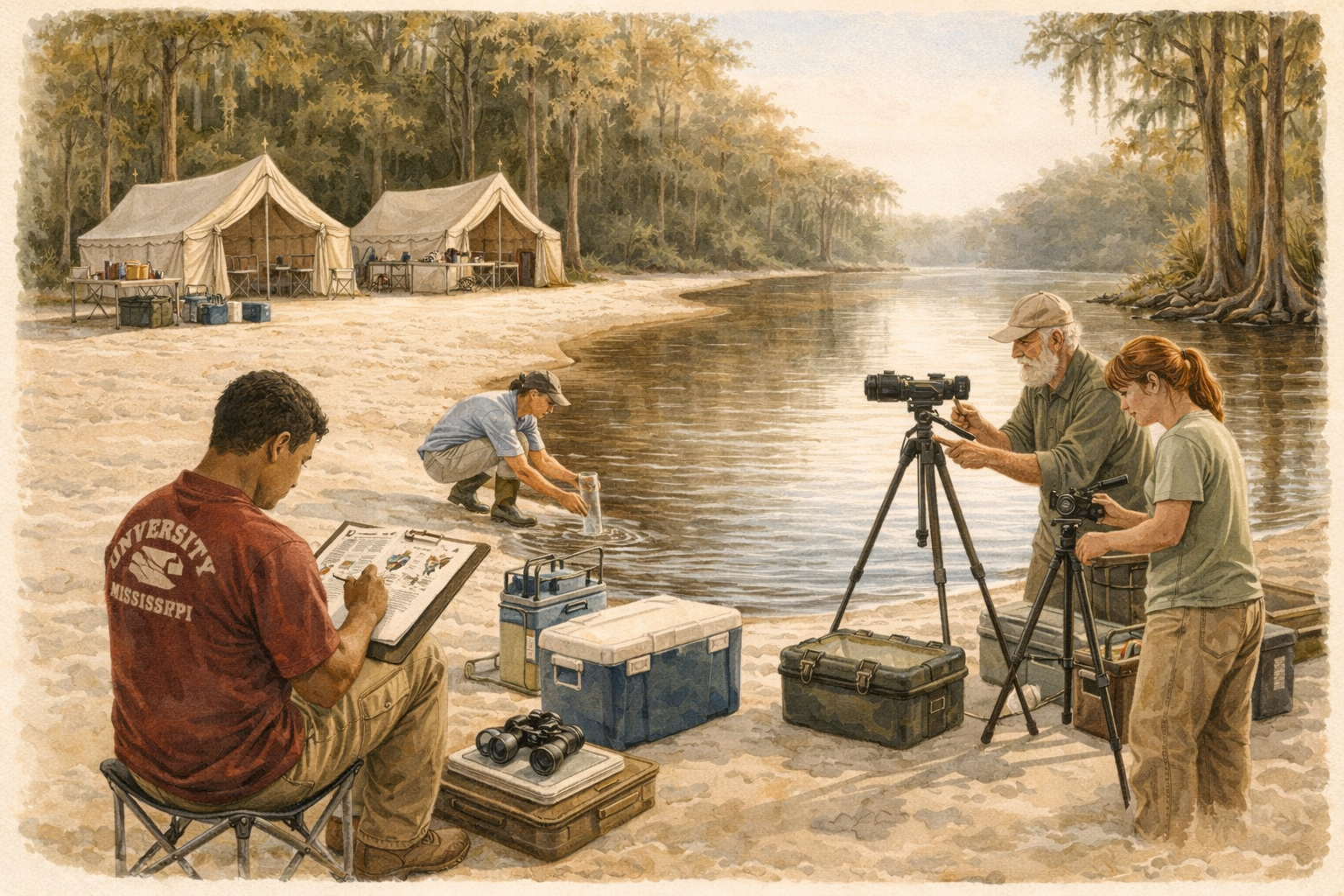
The Expedition
A working research vessel on America's last wild river.

The Leaf-Pascagoula system runs 125 miles from Hattiesburg to the Gulf of Mexico. It is the last major undammed, unchannelized, unleveed river system in the contiguous United States. Scientists compare it to the Serengeti, Amazon Basin, and Florida Everglades.
Conservation significance: The Nature Conservancy purchased 42,000 acres from Pascagoula Hardwood Company in the 1970s, sold to the state for Wildlife Management Areas. Today 37,000 acres of Pascagoula River WMA and 600,000 acres of public lands flank the basin.
Research value: 327 documented bird species. Gulf sturgeon spawning habitat (ESA threatened). Ancient cypress groves with 500+ year specimens. Baseline ecosystem largely intact—rare anywhere in the developed world.
Eagles Flock sits at mile zero of this corridor. The marina provides a permanent launch point for research vessels accessing 125 miles of protected watershed. The vision: a field station partnership with university researchers who need river access, vessel infrastructure, and overnight facilities.
What we provide: Marina infrastructure, research vessel, base camp facilities, corridor access from headwaters to Gulf.
What university partners provide: Research agenda, scientific credibility, grant-writing capacity, student programs, faculty oversight.
Model: FSU Coastal & Marine Lab demonstrates the pattern—hosts researchers worldwide, partners with NOAA and Nature Conservancy, runs public education programs, generates research funding, maintains research vessels.
Primary: USM Gulf Coast Research Lab (existing Pascagoula presence), USM Migratory Bird Research Group, Mississippi State forestry programs.
Agency: MDWFP Wildlife Division (WMA management), NOAA Fisheries (Gulf sturgeon recovery program), US Fish & Wildlife (migratory bird surveys).
Conservation: Pascagoula River Audubon Center (Moss Point), Mississippi Coast Audubon Society, The Nature Conservancy (original land protection partner).
Paying guests generate supplemental revenue and expand the program's reach. Guests participate in actual data collection—their observations contribute to eBird databases, their photos to iNaturalist species records.
Serious naturalists: Birding club expeditions, nature photographers, citizen scientists. Small groups (8-12) with quality optics and expert guides.
Students: Field biology courses, environmental science programs, conservation education groups.
Experience seekers: Retirees, corporate retreats, families seeking authentic outdoor adventure on a working research vessel.
The station network provides an appealing guest experience—overnight stays at river camps, meals prepared on site, comfortable accommodations in a wilderness setting. Research activity provides authenticity that distinguishes this from standard eco-tourism.
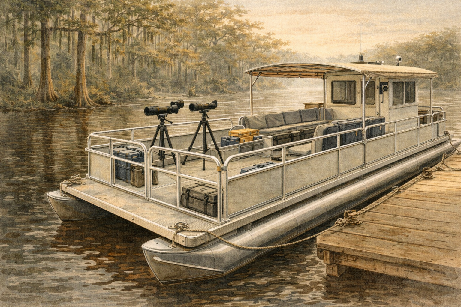
Pontoon platform optimized for observation, not speed. Shallow draft for sandbar access. Stable platform for optics. Quiet operation for wildlife approach.
Capacity: 8-12 guests plus 2-3 crew (expedition leader, captain, naturalist guide).
Range: Full corridor capability—Eagles Flock to Pascagoula (125 miles) over 3 days with overnight stations.
Operations: The vessel doesn't just cruise—it stops. Birders and wildlife photographers need stillness. Drift mode with engine off. Anchored observation at key points. Shore excursions at sandbars and stations.
Permanently Mounted:
| Equipment | Purpose |
|---|---|
| Spotting Scopes (3-4) | Bird/wildlife observation — Swarovski ATX 85mm class on fluid head tripods |
| Digiscoping Stations (3-4) | Guest photography through scopes — PhoneSkope adapters |
| Long-Range Camera | Documentation — 200-600mm lens on gimbal mount |
| Underwater Camera | Fish/aquatic observation — live imaging fishfinder |
| Thermal Imager | Dawn/dusk mammal detection — FLIR Scout class |
| Weather Station | Real-time data logging — lightning detection |
Loaner Fleet:
| Item | Quantity | Notes |
|---|---|---|
| Binoculars | 12-16 pair | Vortex Diamondback HD 8x42 — quality but replaceable |
| Field Guides | 12+ copies | Sibley Southeast, Reptiles/Amphibians of MS, Trees of SE US |
| Data Clipboards | 12 | Waterproof, standardized observation forms |
| Tally Counters | 12 | Species counting protocols |
Rain/Sun Shelter Features:
Roll-down clear vinyl panels maintain visibility in rain. Overhead fans for summer heat. Padded bench seating facing outboard. Individual charging stations (USB-C, USB-A). Cup holders, equipment racks. Engine and generator noise isolated from observation deck.
Lab/Processing Area:
| Station | Equipment |
|---|---|
| Photo Processing | MacBook Pro, external displays, card readers, backup drives |
| Microscope Station | Stereo microscope for plankton/insect samples |
| Water Quality | pH meter, conductivity tester, Secchi disk, sample containers |
| Specimen Reference | Laminated ID cards, preserved specimens, skull/track molds |
| Data Entry | iPads with eBird, iNaturalist, custom expedition database |
Equipment list and costs under development. Categories include optics (spotting scopes, binoculars), camera systems, water quality testing, data collection tools, and loaner equipment for guests.
Status: Specifications defined. Vendor quotes pending.
Three permanent stations along the 125-mile corridor. Each with communications infrastructure, guest accommodations, and research facilities. The boat serves as mobile transport between stations.
Model: African safari camps, Antarctic research stations, Amazon field stations—but accessible to the public. Glamping infrastructure with serious research capability.
Function: Departure point, headquarters, primary marina
Existing/Planned: Eagles Flock marina (25 slips), public boat ramp, connection to Hattiesburg (supplies, airport, medical).
Research Network Additions:
| Facility | Purpose |
|---|---|
| Research Center Building | Equipment storage, briefing room, photo lab |
| Guest Check-in | Orientation, valise distribution, parking |
| Emergency Response | Vehicle, first aid, communications hub |
Function: Mid-point station, river confluence observation, overnight
Location: Near Merrill Bridge, where Leaf meets Chickasawhay to form the Pascagoula. Geographic significance (two rivers become one), historic 1928 bridge (Mississippi Landmark), accessible by road.
Glamping Infrastructure:
| Structure | Qty | Specification |
|---|---|---|
| Safari Tents (Guest) | 6 | 24m² each, king bed, en-suite bathroom, climate control |
| Research Tent (Lab) | 1 | 46m², wet lab, microscopes, sample storage |
| Common House | 1 | Dining, kitchen, gathering space, screened porch |
| Equipment Shed | 1 | Kayaks, sampling gear, emergency supplies |
Utilities: Solar array + battery bank + propane generator backup. Well or rainwater catchment + filtration. Composting toilets, gray water treatment.
Build Cost: TBD — no bids received.
Function: Deep wilderness station, WMA access, maximum wildlife
Location: Historic Wilkerson Ferry site, Pascagoula River WMA. Already has primitive facilities (port-a-lets, artesian well). Heart of 37,000-acre WMA. Maximum wildlife density. State already permits camping.
Glamping Infrastructure:
| Structure | Qty | Specification |
|---|---|---|
| Safari Tents (Guest) | 4 | 24m² each, slightly more rustic than Merrill |
| Research Tent | 1 | 36m², field lab, bird banding station |
| Observation Tower | 1 | 30-40 ft, canopy-level birding |
| Floating Dock | 1 | Boat tie-up, fishing platform |
This is the "wild" camp—guests who want more adventure stay here. Guests who want more comfort can take the boat back to Merrill.
Build Cost: TBD — no bids received.
The solved problem: Starlink + satellite messengers + VHF radio network provides reliable communication throughout the corridor.
Equipment: Starlink terminals at each station, Starlink Roam on vessel, VHF base stations, Garmin inReach satellite messengers, weather stations.
Cost: Equipment and service costs TBD — specifications defined, quotes pending.
| Mile | Location | Feature |
|---|---|---|
| 0 | Eagles Flock | Marina, base camp, departure |
| 0-24 | Upper Leaf | Bald eagles, kingfishers, sandbars, rapids |
| 24 | Buck Creek / Old Augusta | James Copeland site, 1812 county seat |
| 28 | Wingate Cove | Bogue Homa Creek, swimming sandbar |
| 37 | Hwy 15 / Beaumont | DeSoto National Forest corridor |
| 52 | Hwy 98 / McLain | Historic bridges, logging era sites |
| 67 | Merrill | Confluence, 1928 bridge, Station 2 |
| 67-90 | Pascagoula WMA | Giant cypress, alligators, black bears |
| 90 | Wilkerson Ferry | Historic ferry site, Station 3 |
| 90-110 | Lower Pascagoula | Gulf sturgeon habitat, tidal transition |
| 110 | Moss Point | Audubon Center, marinas |
| 125 | Pascagoula | Singing River, lighthouse, Gulf |
Wildlife Biology: 327 bird species documented. Gulf sturgeon (ESA threatened). River otter, black bear, alligator populations. Swallow-tailed Kite nesting surveys.
Hydrology: Rain gauges, stream gauges, flood monitoring. Water quality transects. Baseline data for undammed system—increasingly rare reference point.
Archaeology: 25,000 years of human use documented. Choctaw Six Towns territory. Spanish trading routes. Timber rafting era sites.
Forestry/Botany: Ancient cypress (500+ year specimens). Longleaf pine restoration. Invasive species mapping (Salvinia, Asian clam).
eBird Integration: The world's largest biodiversity database. Expedition Leader enters sightings in real-time. Guests learn proper identification and counting protocols. Rare species trigger "checklist review"—guest becomes documented observer. Each trip generates a shareable eBird Trip Report.
iNaturalist Documentation: Photos uploaded with GPS coordinates. AI identification + community verification. Research Grade observations become part of scientific literature.
Custom Data Collection: Bald eagle nest monitoring. Gulf Sturgeon photo-ID (if encountered). Invasive species documentation. Cypress tree measurements (citizen "Big Tree" program). Water quality transects contributing to Pascagoula monitoring.
Track A: Student/Research Residencies
Graduate students, undergraduate field courses, visiting researchers, citizen science volunteers. Duration: 1-8 weeks. Accommodation: shared tents, research tent access, communal meals. Pricing structure TBD based on university partnership terms.
Track B: Experience Guests (Paying)
Birding club trips, nature photographers, retirees, corporate team-building, families. Duration: 2-4 days. Accommodation: private safari tents, quality meals, full service. Pricing TBD.
The interaction: Guests see real scientists doing real work. Students get stipend support from guest revenue. Both contribute to the same data sets.
Each guest receives a leather or waxed canvas expedition valise containing tangible evidence of participation:
| Item | Description |
|---|---|
| Expedition Field Journal | Leather-bound with waterproof pages, pre-printed species checklists |
| Species Checklist | Laminated card showing all species observed, with checkmarks |
| USB Drive | Personal photos, trip video highlights, eBird trip report PDF, GPS track |
| Cypress Medallion | Laser-cut slice of salvaged cypress with expedition date engraved |
| Research Certificate | "Citizen Science Contributor" citing eBird checklists, iNaturalist count |
| Photo Print | One professional-quality print, signed by Expedition Leader |
| Sound Recording | QR code to audio: Singing River phenomenon + dawn chorus |
| Pressed Specimen | Properly mounted native leaf with botanical ID |
| Map | Custom illustrated route with GPS coordinates of major sightings |
Day 1: Eagles Flock to Merrill (67 miles)
Dawn departure with coffee and briefing. Upper Leaf River rapids and sandbars. Bald eagle nest monitoring. Swimming sandbar stop with water quality sampling. Hot lunch served aboard. Approach to Merrill confluence where two rivers merge. Historic Merrill Bridge (1928) walking tour. Evening data entry and presentation on Singing River legend.
Day 2: Merrill to Wilkerson Ferry (23 miles)
Pre-dawn departure into Pascagoula River WMA. Giant cypress groves at Upper Rhymes Lake. Alligator counting protocol. Black bear sign observation. Oxbow lake kayak shuttle and plankton sampling. Evening at historic Wilkerson Ferry with star party (no light pollution) and night thermal imaging session.
Day 3: Wilkerson Ferry to Pascagoula (35 miles)
Pack out (Leave No Trace). Tidal transition zone and brackish water species shift. Stop at Pascagoula River Audubon Center. Singing River listening station near I-10 bridge. Valise presentation ceremony. Group photo at Round Island Lighthouse.

Planning Grants: Up to $25,000 for 5-10 year strategic plans. Produces the required strategic plan document for larger infrastructure grants.
Improvement Grants: Historically up to $500K for facilities, equipment, communications infrastructure.
Requirements: Significant fraction of research must be NSF-eligible. University partnership (USM, MSU) strengthens application substantially.
Annual funding: ~$16-18M across all FSML programs, 40-60 awards nationally.
Strategic path: Start with Planning Grant ($25K) to produce required strategic plan, then apply for Improvement Grant for station infrastructure.
Track record: Already funded Leaf River access—Sims Road boat ramp ($480K + $225K city match) in the same corridor.
Recent awards: $37M released in 3 years. $9.8M for 21 projects (2023). $13.4M for 28 projects (2025).
Priorities: Eco-tourism, environmental education, conservation, public access.
Match requirements: Typically requires matching funds, which can come from private donations, in-kind contributions, or other grants.
Active research: $2.5M study on Gulf sturgeon migration patterns in Pascagoula River currently underway.
Funding source: NOAA Gulf Spill Restoration funds continue to flow for ecosystem restoration and research.
Strategy: Partner with existing researchers to add credibility. Gulf sturgeon presence in corridor provides ESA-listed species hook for federal funding.
Grants for programs using Earth system science for ecosystem stewardship. Focus on building resilience to environmental hazards.
Supports formal (K-12) and informal education programs. Citizen science components align well with expedition model.
Gulf Coast Conservation Grants: Supports innovative restoration, youth/veteran engagement, species/habitat projects.
Gulf-specific funding stream with annual grant cycles. Conservation education and research components align with expedition program.
Capital Investment: TBD — station construction, communications network, vessel equipment, permitting. No bids received.
Annual Operating: TBD — communications, utilities, insurance, staff, supplies, maintenance, marketing.
Revenue Model: Under development. Sources include expeditions, research residencies, day tours, university contracts, grants.
Hattiesburg sits at mile zero of America's last undammed river system. The Leaf River flows through the city, yet no organized program exists to connect residents and visitors to this globally significant resource.
City sponsorship transforms a private marina proposal into a public-benefit research station — the gateway to a 125-mile corridor that scientists compare to the Serengeti and Amazon Basin.
Visitor capture: Expedition guests fly into Hattiesburg-Laurel Regional Airport, stay in Hattiesburg hotels before departure, purchase supplies locally, and return to the city after multi-day trips. Tourism dollars that currently bypass the city get captured.
New market segment: Birding tourism is a $40+ billion industry nationally. Nature photographers, citizen scientists, university field courses — these visitors don't currently come to Hattiesburg. The expedition program creates a reason.
Extended stays: Multi-day expeditions mean multi-night hotel bookings, multiple restaurant meals, retail purchases. This isn't day-trip tourism — it's destination tourism.
Hattiesburg sits at the confluence of the Leaf and Bouie rivers but hasn't built an identity around water the way San Antonio did with the River Walk or Chattanooga did with the Tennessee River.
The positioning: "Gateway to America's Last Wild River" — a national-scale story that differentiates Hattiesburg from the coast (casinos, beaches) and Jackson (state capital).
Conservation credibility: The city gets associated with protecting a globally significant ecosystem without having to acquire or manage land. The WMA is state-owned, Eagles Flock is private — Hattiesburg provides sponsorship and gains the recognition.
USM is in Hattiesburg. City sponsorship creates a three-way partnership: municipal economic development + university research mission + private infrastructure operator.
Grant leverage: Federal funding programs (NSF, NOAA, NFWF) favor applications showing local government, academic institution, and private enterprise aligned. City involvement strengthens every grant application for the corridor.
Student programs: USM biology, marine science, and environmental studies programs gain a permanent field station. Students do research in their own backyard. Faculty get publication opportunities. The city's university becomes known for river ecology.
Eagles Flock sits in the floodway. Development requires demonstrating public benefit — private commercial use alone won't satisfy permitting requirements.
The transformation: City sponsorship reframes the project from "private marina in floodway" to "public research station providing citizen access to nationally significant natural resource."
Flood-compatible design: Safari tents, floating docks, and elevated platforms work with seasonal flooding rather than fighting it. This is how African safari camps operate — flood cycles are features, not problems.
Resilience research value: An undammed river system is a living laboratory for natural floodplain function. With climate change increasing flood frequency, baseline data from an intact system has scientific and policy value. The city sponsors forward-thinking resilience work.
Hattiesburg already executed a successful river access project in this corridor — the Sims Road boat ramp received $480,000 from the Mississippi Outdoor Stewardship Trust Fund plus $225,000 city match.
Proven capability: The city knows how to apply for and manage MOSTF grants. The expedition program is the logical next step — not just a boat ramp, but a destination that activates the access point they already built.
Complementary infrastructure: Sims Road provides public launch access. Eagles Flock provides the marina, vessel, and station network. Together they create a complete system.
K-12 field trips: Hattiesburg students access an outdoor classroom on a river system of global scientific significance. Field biology becomes local, not abstract.
Citizen science: Residents participate in eBird surveys, water quality monitoring, species documentation. The data contributes to real research — people become stakeholders in their own river.
Community expeditions: Subsidized or sponsored trips for youth groups, veterans, seniors. The program serves Hattiesburg residents, not just visiting tourists.
The river is named for the Pascagoula tribe ("bread people"). When the Pascagoula faced extinction at the hands of the Biloxi tribe, they joined hands and walked into the river, chanting and singing until the last voice was silenced by the waters.
To this day, people report hearing the river "sing"—a humming sound in late summer, especially near the I-10 bridge at Pascagoula. Whether acoustic phenomenon or cultural memory, the story reflects the region's deep indigenous history.
Choctaw Connection: The Choctaw's historic homeland boundary was "the Leaf-Pascagoula system to the South." Evidence of 25,000+ years of human habitation in river corridor. Archaeological "ancient river terraces and cultural remnants from indigenous populations" documented in Pascagoula River WMA.
The Leaf and Pascagoula Rivers were industrial highways for the lumber industry. Virgin longleaf pine was floated to coastal sawmills.
L.N. Dantzler Lumber Company at Moss Point kept a log brand book with over 5,000 different brands used on logs rafted down the Pascagoula and tributaries (1865-1930). Half-million logs per year floated to Moss Point-Pascagoula mills.
Captain Benjamin Stevens (1867) started timber operation rafting virgin pine logs from Augusta down the Leaf and Pascagoula to Gulf Coast sawmills.
"Deadheads"—sunken logs from the rafting era remained preserved underwater; recovered 1915-1930 as timber source. The "rafters" were described as "a vigorous and hearty breed" who guided log rafts downstream, camping on the same sandbars that visitors use today.
Merrill is where the Leaf River (dark, clear water) meets the Chickasawhay River (pale, silty water) to form the Pascagoula.
Historic Merrill Bridge: Built 1928—oldest intact bridge over the Pascagoula River. First bridge to cross the Pascagoula (replaced a ferry). Mississippi Landmark—now closed to vehicles, open to foot traffic. From the bridge, visitors can see the confluence of the two rivers.
Historic Merrill Town: Once had nine general stores, three turpentine distilleries, two sawmills, a drugstore. Post office operated 1898-1960. On the former Gulf, Mobile and Ohio Railroad.
The Pascagoula River WMA contains trees exceeding 30 feet in circumference. Some specimens estimated at 500+ years old.
| Tree Species | Habitat | Notes |
|---|---|---|
| Bald Cypress | River edges, swamps | Knees visible at low water, buttressed trunks |
| Tupelo Gum | Flooded timber | Swollen base, fall color |
| Water Tupelo | Permanently flooded | Similar to cypress habitat |
| River Birch | Banks | White peeling bark |
| Sycamore | Banks | Mottled white bark |
Key Viewing: Upper Rhymes Lake (giant cypress, tupelo, cypress knees), Lower Rhymes Lake (oxbow with ancient flooded timber), Parker Lake (moss-draped cypress "exceeding 30 feet in circumference").
Old Augusta (Buck Creek boat ramp area) was the original Perry County seat, established 1812.
The James Copeland Story: October 30, 1857—notorious outlaw James Copeland was hanged at Old Augusta. Copeland led a "criminal rampage of robbing and murder throughout the southern U.S." before the Civil War. He gave deathbed confessions to Perry County Sheriff J.R.S. Pitts, published as Life and Confession of the Noted Outlaw James Copeland.
Why the Town Moved: New Augusta (2 miles south) was established 1902-1906 to be on the new Mobile, Jackson & Kansas City Railroad. Old Augusta remains a small village today—scant remnants near the boat ramp.
Eagles Flock
A new neighborhood in the works on the Leaf River
Proposed pricing: $200,000 – $375,000
 Community playground · Safe outdoor play for all ages
RE/MAX Real Estate Partners
119 Mayfair Rd, Hattiesburg, MS 39402
Office: (601) 296-2001 · Cell: (601) 606-3001
License #S45964
Interested in Eagles Flock?
103 new homes on the Leaf River. First marina in Hattiesburg.
Get More Information